Summary
The GT_SORTEDPOLY command in GeoTools creates a polyline by connecting selected points in a sorted sequence, based on user-defined sorting criteria in BricsCAD, AutoCAD, ZWCAD and ARES Commander.
GeoTool -> Draw Tools -> Draw Tools -> Draw a polyline by joining points in sorted order
Draw a Polyline by Joining Points in Sorted Order: GT_SORTEDPOLY – GeoTools Command
Draw a Polyline by Joining Points in Sorted Order: GT_SORTEDPOLY – GeoTools Command
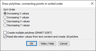
Key Features Include:
- Sorting Options for Point Connection:
- Increasing X values – Connects points from left to right along the X-axis.
- Increasing Y values – Connects points from bottom to top along the Y-axis.
- Decreasing X values – Connects points from right to left along the X-axis.
- Decreasing Y values – Connects points from top to bottom along the Y-axis.
- Advanced Polyline Creation Options:
- Create Multiple Polylines (SMART SORT) – Automatically detects breaks and generates multiple polylines.
- Read Elevation Values from Text and Create 3D Polyline – Extracts elevation data from text objects to form 3D polylines instead of 2D.
Benefits:
This tool is particularly useful for surveying, GIS applications, and topographical modeling, where points need to be connected logically to form structured polylines.