Summary
The GEOL_STRATABUILDER command in GeoTools enables users to generate and visualize borehole lithology strata in multiple formats, making it an essential tool for geologists, geotechnical engineers, and mining professionals in BricsCAD, AutoCAD, ZWCAD and ARES Commander.
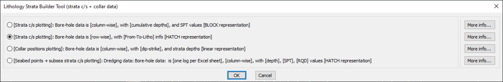
GeoTool -> Geological/Mining Tools -> Bore-Hole -> Draw bore-hole strata [LITHOLOGY] in different ways
Draw Bore-Hole Strata [LITHOLOGY] in Different Ways: GEOL_STRATABUILDER – GeoTools Command
Draw Bore-Hole Strata [LITHOLOGY] in Different Ways: GEOL_STRATABUILDER – GeoTools Command
Draw Bore-Hole Strata [LITHOLOGY] in Different Ways: GEOL_STRATABUILDER – GeoTools Command
Draw Bore-Hole Strata [LITHOLOGY] in Different Ways: GEOL_STRATABUILDER – GeoTools Command
Draw Bore-Hole Strata [LITHOLOGY] in Different Ways: GEOL_STRATABUILDER – GeoTools Command
Draw Bore-Hole Strata [LITHOLOGY] in Different Ways: GEOL_STRATABUILDER – GeoTools Command
Key Features Include:
- Multiple Lithology Strata Plotting Methods:
- Strata Cross-Section (C/S) Plotting (Column-wise)
- Uses cumulative depths and SPT (Standard Penetration Test) values.
- Displays lithology as BLOCK representations.
- Strata Cross-Section (C/S) Plotting (Row-wise)
- Uses From-To lithology information for better depth-based representation.
- Displays lithology using HATCH representations for clear visualization.
- Collar Position Plotting
- Displays borehole data in column format with dip-strike and depth values.
- Uses a linear representation for strata positioning.
- Seabed Points & Subsea Strata Plotting
- Specially designed for dredging data.
- Processes borehole logs from Excel files (one log per sheet).
- Includes depth, SPT, and RQD (Rock Quality Designation) values with HATCH representation.
- Strata Cross-Section (C/S) Plotting (Column-wise)
- Customizable Borehole Data Representation:
- Selects borehole data based on column-wise or row-wise structure.
- Uses From-To depth relationships to depict lithological changes.
- Supports various borehole attributes, including SPT, RQD, and depth intervals.
Benefits:
This tool is essential for subsurface investigation, soil analysis, and geological modeling, providing a flexible and visually effective way to interpret borehole lithology.