Summary
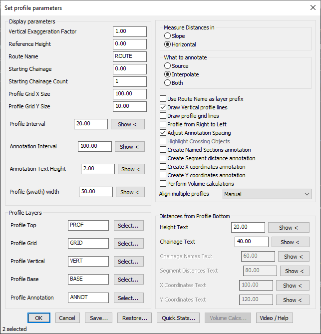
The GT_PROFILE command is used to create longitudinal profiles from 3D polylines. It effectively plots elevation values along the Y-axis while displaying chainages (distances) along the X-axis.
GeoTool -> Geological/Mining Tools -> General -> Draw cross-sectional profile from 3D Polyline
Draw Cross-Sectional Profile from 3D Polyline: GT_PROFILE – GeoTools Command
Key Features Include:
- Profile Generation & Annotation:
- Extracts profiles from 3D polylines and represents elevation changes over distance.
- Supports named section annotations, segment distance labels, and X/Y coordinate annotations.
- Adjusts annotation spacing to prevent overlapping text.
- Measurement & Annotation Options:
- Measurement in Slope or Horizontal mode for accurate profiling.
- Annotate at each vertex, interpolated points, or both.
- Supports vertical exaggeration factor to adjust scale representation.
- Grid & Formatting Controls:
- Customizable profile grid spacing for X and Y dimensions.
- Allows drawing vertical profile lines and grid lines for better readability.
- Configurable profile width (swath width) to define the horizontal extent of the section.
- Crossing Object Detection:
- Identifies and highlights objects (blocks and shapes) that cross the profile line.
- Data Export & Configuration Management:
- Chainage data and profile details can be saved as CSV files for use in Excel or GIS applications.
- Profile settings can be saved and restored for consistency in multiple projects.
Benefits:
This tool is ideal for surveying, road design, drainage analysis, and infrastructure planning, providing a detailed elevation representation of a selected route or alignment.