Summary
The GT_EMBHATCH command in GeoTools creates a hatch pattern with alternating long and short lines to represent embankment slopes, ensuring accurate terrain visualization in BricsCAD, AutoCAD, ZWCAD and ARES Commander.
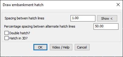
GeoTool -> Draw Tools -> Draw Tools -> Draw Embankment hatch slopes pattern
Key Features Include:
- Customizable Hatch Line Spacing:
- Define the spacing between hatch lines for precise pattern control.
- Adjust the percentage spacing between alternate hatch lines to set the ratio of long and short lines.
- Requires Two Boundary Lines:
- The embankment hatch is generated between two selected boundaries, which must be lines or polylines.
- Supports Linear Geometry:
- The command works only on straight-line segments (not curved).
- Additional Hatch Options:
- Double Hatch – Creates a denser hatch pattern for enhanced visualization.
- Hatch in 3D – Generates hatch lines in 3D with elevation input, improving terrain annotation and slope analysis.
Benefits:
This tool is essential for civil engineers, surveyors, and topographical drafters, providing a structured method for embankment slope representation in CAD drawings.