Summary
The GEOL_RUNNINGPATTERNS command in GeoTools is designed to create running patterns representing various topographic and geological formations, making it a valuable tool for geologists, civil engineers, and GIS professionals working in BricsCAD, AutoCAD, ZWCAD and ARES Commander.
GeoTool -> Geological/Mining Tools -> General -> Draw geological patterns
Key Features Include:
- Multiple Geological Pattern Types:
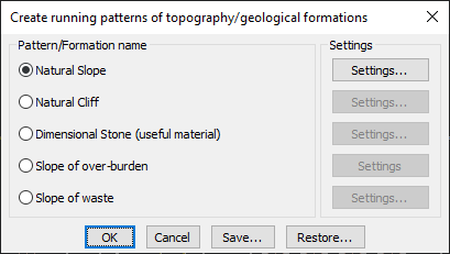
- Natural Slope – Represents gradual terrain slopes.
- Natural Cliff – Depicts steep rock faces or cliffs.
- Dimensional Stone (Useful Material) – Marks areas containing extractable stone resources.
- Slope of Over-Burden – Identifies loose material over valuable resources.
- Slope of Waste – Maps areas designated for excavation waste.
- Customizable Settings:
- Each geological formation type includes configurable pattern settings for precise representation.
- Users can fine-tune line styles, density, and orientations.
- Efficient Map Representation:
- Ideal for geological surveys, mining plans, and topographic mapping.
- Helps in visualizing terrain features in CAD environments.
- Save & Restore Configurations:
- Users can save and restore predefined settings, ensuring consistency across multiple projects.
Benefits:
This tool is essential for professionals needing clear, visual geological patterning for terrain analysis, mining projects, and environmental planning.