Customize Consent Preferences

We use cookies to help you navigate efficiently and perform certain functions. You will find detailed information about all cookies under each consent category below.

The cookies that are categorized as "Necessary" are stored on your browser as they are essential for enabling the basic functionalities of the site. ... 

Always Active

Necessary cookies are required to enable the basic features of this site, such as providing secure log-in or adjusting your consent preferences. These cookies do not store any personally identifiable data.

No cookies to display.

Functional cookies help perform certain functionalities like sharing the content of the website on social media platforms, collecting feedback, and other third-party features.

No cookies to display.

Analytical cookies are used to understand how visitors interact with the website. These cookies help provide information on metrics such as the number of visitors, bounce rate, traffic source, etc.

No cookies to display.

Performance cookies are used to understand and analyze the key performance indexes of the website which helps in delivering a better user experience for the visitors.

No cookies to display.

Advertisement cookies are used to provide visitors with customized advertisements based on the pages you visited previously and to analyze the effectiveness of the ad campaigns.

No cookies to display.

GeoTools

Draw Graded Polylines: GT_DRAWGRADE – GeoTools Command

Summary

The GT_DRAWGRADE command in GeoTools enables the creation of graded 3D polylines or lines with precise slope control, essential for civil engineering, site grading, and infrastructure design in BricsCAD, AutoCAD, ZWCAD and ARES Commander.

GeoTool -> Geological/Mining Tools -> General -> Draw Graded polylines

Draw Graded Polylines: GT_DRAWGRADE – GeoTools Command

Key Features Include:

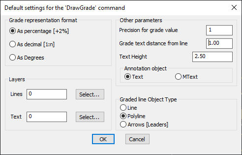
  • Flexible Grade Representation:
    • Percentage (+2%)
    • Decimal (1:n)
    • Degrees
  • Multiple Output Object Types:
    • 3D Polylines for direct grading representation.
    • Lines for simpler slope depiction.
    • Leaders with Arrows for annotation-based slope visualization.
  • Layer Control: Assign specific layers for graded lines and text annotations.
  • Precision Settings: Define grade value precision and text height for clear annotation.
  • Customizable Annotation Placement:
    • Choose between Text or MText annotation styles.
    • Adjust grade text distance from the line for optimal readability.

Benefits:

This tool is perfect for roadway design, landscape modeling, and slope analysis, allowing users to create visually clear and dimensionally accurate grading representations.

Leave a Comment

Your email address will not be published. Required fields are marked *