Summary
The GEOL_LEASEAREADRAW command in GeoTools enables users to create mining lease area maps by drawing key feature classes such as lease boundaries, land classifications, and infrastructure elements. This command is essential for mine planning, land management, and environmental compliance in BricsCAD, AutoCAD, ZWCAD and ARES Commander.
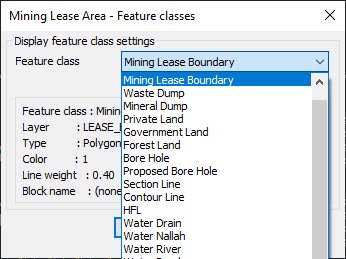
GeoTool -> Geological/Mining Tools -> General -> Draw Lease Area Map Elements
Key Features Include:
- Comprehensive Feature Class Library:
- Supports multiple mining and land-use features, including:
- Mining Lease Boundary
- Waste Dump, Mineral Dump
- Private Land, Government Land, Forest Land
- Bore Hole, Proposed Bore Hole
- Contour Line, Section Line
- Water Features (Drain, Nallah, River) Etc.
- Supports multiple mining and land-use features, including:
- Layer-Based Mapping:
- Each feature is assigned to a dedicated CAD layer for structured visualization.
- Configurable line weight, color, and block assignment for precise representation.
- Efficient Lease Area Mapping:
- Automates the creation of lease boundaries and associated features.
- Ideal for regulatory compliance and reporting in mining projects.
Benefits:
This tool is particularly useful for mine surveyors, environmental planners, and GIS professionals requiring detailed mining lease area maps for planning and documentation.