Customize Consent Preferences

We use cookies to help you navigate efficiently and perform certain functions. You will find detailed information about all cookies under each consent category below.

The cookies that are categorized as "Necessary" are stored on your browser as they are essential for enabling the basic functionalities of the site. ... 

Always Active

Necessary cookies are required to enable the basic features of this site, such as providing secure log-in or adjusting your consent preferences. These cookies do not store any personally identifiable data.

No cookies to display.

Functional cookies help perform certain functionalities like sharing the content of the website on social media platforms, collecting feedback, and other third-party features.

No cookies to display.

Analytical cookies are used to understand how visitors interact with the website. These cookies help provide information on metrics such as the number of visitors, bounce rate, traffic source, etc.

No cookies to display.

Performance cookies are used to understand and analyze the key performance indexes of the website which helps in delivering a better user experience for the visitors.

No cookies to display.

Advertisement cookies are used to provide visitors with customized advertisements based on the pages you visited previously and to analyze the effectiveness of the ad campaigns.

No cookies to display.

GeoTools

Draw Parcel Lots Tool: GT_LOTMAKER – GeoTools Command

Summary

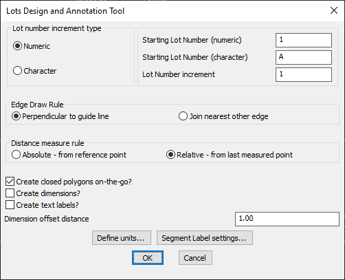
The GT_LOTMAKER command in GeoTools is used to design and annotate parcel lots, providing a structured way to create lot boundaries, apply numbering, and generate dimension labels in BricsCAD, AutoCAD, ZWCAD and ARES Commander.

GeoTool -> Draw Tools -> Draw Tools -> Draw parcel-Lots Tool

Draw Parcel Lots Tool: GT_LOTMAKER – GeoTools Command

Key Features Include:

  • Lot Numbering System:
    • Supports numeric and character-based lot numbering.
    • Allows setting a starting lot number and custom increment value.
  • Edge Draw Rule:
    • Perpendicular to Guide Line – Ensures lot boundaries are drawn at a right angle to a reference line.
    • Join Nearest Other Edge – Connects lots to the closest existing boundary.
  • Distance Measurement Options:
    • Absolute (From Reference Point) – Measures from a fixed starting point.
    • Relative (From Last Measured Point) – Measures from the previous point for continuous plotting.
  • Additional Lot Design Features:
    • Create Closed Polygons On-the-Go – Automatically generates closed lot boundaries as polygons.
    • Create Dimensions – Adds dimension annotations to the lot boundaries.
    • Create Text Labels – Inserts lot number text labels for easy identification.
  • Customization Controls:
    • Dimension Offset Distance – Defines spacing for dimension annotations.
    • Define Units & Label Settings – Allows users to configure measurement units and segment labeling preferences.

Benefits:

This tool is essential for urban planners, surveyors, and land developers, enabling efficient lot creation and annotation in CAD drawings.

Leave a Comment

Your email address will not be published. Required fields are marked *