Customize Consent Preferences

We use cookies to help you navigate efficiently and perform certain functions. You will find detailed information about all cookies under each consent category below.

The cookies that are categorized as "Necessary" are stored on your browser as they are essential for enabling the basic functionalities of the site. ... 

Always Active

Necessary cookies are required to enable the basic features of this site, such as providing secure log-in or adjusting your consent preferences. These cookies do not store any personally identifiable data.

No cookies to display.

Functional cookies help perform certain functionalities like sharing the content of the website on social media platforms, collecting feedback, and other third-party features.

No cookies to display.

Analytical cookies are used to understand how visitors interact with the website. These cookies help provide information on metrics such as the number of visitors, bounce rate, traffic source, etc.

No cookies to display.

Performance cookies are used to understand and analyze the key performance indexes of the website which helps in delivering a better user experience for the visitors.

No cookies to display.

Advertisement cookies are used to provide visitors with customized advertisements based on the pages you visited previously and to analyze the effectiveness of the ad campaigns.

No cookies to display.

GeoTools

Draw Vegetation Cover Symbols: GT_VEGLINE – GeoTools Command

Summary

The GT_VEGLINE command in GeoTools creates vegetation cover line patterns using arced polylines, allowing users to define the size, shape, and pattern of arcs in BricsCAD, AutoCAD, ZWCAD and ARES Commander.

GeoTool -> Draw Tools -> Draw Tools -> Draw vegetation cover symbols

Draw Vegetation Cover Symbols: GT_VEGLINE – GeoTools Command

Key Features Include:

  • Customizable Arc Properties:
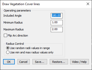
    • Included Angle – Defines the arc angle for vegetation patterns.
    • Minimum & Maximum Radius – Sets the range of arc sizes.
    • Flip Arc Direction – Reverses the curvature of the arcs for pattern variation.
  • Radius Control:
    • Use Random Radii Values in Range – Generates vegetation arcs with random radii within the specified range.
    • Use Min and Max Radius Values Only – Restricts arcs to either minimum or maximum radius.
  • Save & Restore Settings:
    • Users can save and reload parameter settings for consistent vegetation pattern generation.
  • Layer Placement Options:
    • Source Layer – Places the generated pattern in the original object’s layer.
    • Current Layer – Inserts the pattern into the active layer.
    • Specify Custom Layer – Allows users to define a target layer for placement.
  • Option to Delete Original Objects:
    • Users can choose to remove the original polylines after generating vegetation cover lines.

Benefits:

This tool is useful for landscape design, environmental mapping, and topographical representation, ensuring an efficient and visually accurate depiction of vegetation cover in CAD drawings.

Leave a Comment

Your email address will not be published. Required fields are marked *