Summary
The GT_FINDZRNG command in GeoTools allows users to select all objects whose Z-values (elevations) fall within a defined range. This tool is essential for surveyors, GIS professionals, and CAD drafters working in BricsCAD, AutoCAD, ZWCAD and ARES Commander.
GeoTool -> Selection Tools -> Selection Tools -> Find objects in selected Z range
Key Features Include:
- Elevation-Based Object Selection:
- Filters and selects objects within a user-specified Z-range.
- Helps in identifying elevation-specific entities in CAD drawings.
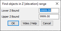
- Customizable Z-Range Input:
- Users can set lower and upper Z bounds to refine selection.
- Default values cover a wide range (-9999 to 9999), allowing flexibility.
- Practical Applications:
- QA/QC for Elevation Data – Ensures that objects have correct Z-values.
- Contour & Terrain Analysis – Isolates features at specific elevation bands.
- 3D Model Cleanup – Detects objects with incorrect or unwanted Z-values.
Benefits:
This tool is particularly useful for validating elevation data and ensuring accuracy in 3D CAD models.