Summary
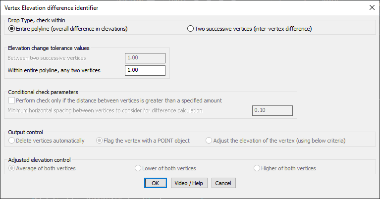
The GT_VXDROP command in GeoTools is designed to analyze polylines, lines, splines, and 3D faces and identify elevation variations exceeding a user-defined threshold. It ensures precise elevation management within BricsCAD, AutoCAD, ZWCAD, and ARES Commander.
GeoTool -> Polyline Tools -> Identify -> Highlight Elevation Differences in Polylines
Key Features Include:
- Elevation Difference Analysis – Detects variations in vertex elevations across selected entities.
- Customizable Drop Type Checks:
- Entire polyline check – Evaluates the overall elevation difference across the polyline.
- Two successive vertices check – Identifies elevation differences between consecutive vertices.
- Tolerance Control:
- Set specific elevation change limits for successive vertices or any two vertices in a polyline.
- Conditional Check Parameters:
- Option to ignore differences when vertices are within a defined horizontal spacing threshold.
- Output Control:
- Delete vertices automatically – Removes vertices that do not meet elevation criteria.
- Flag the vertex with a POINT object – Marks the vertex for further review.
- Adjust the elevation of the vertex – Modifies the elevation using predefined adjustment methods.
- Elevation Adjustment Options:
- Average of both vertices
- Lower of both vertices
- Higher of both vertices
Benefits:
This tool is essential for professionals handling terrain modeling, topographical mapping, and infrastructure planning, ensuring elevation consistency across CAD designs.