Customize Consent Preferences

We use cookies to help you navigate efficiently and perform certain functions. You will find detailed information about all cookies under each consent category below.

The cookies that are categorized as "Necessary" are stored on your browser as they are essential for enabling the basic functionalities of the site. ... 

Always Active

Necessary cookies are required to enable the basic features of this site, such as providing secure log-in or adjusting your consent preferences. These cookies do not store any personally identifiable data.

No cookies to display.

Functional cookies help perform certain functionalities like sharing the content of the website on social media platforms, collecting feedback, and other third-party features.

No cookies to display.

Analytical cookies are used to understand how visitors interact with the website. These cookies help provide information on metrics such as the number of visitors, bounce rate, traffic source, etc.

No cookies to display.

Performance cookies are used to understand and analyze the key performance indexes of the website which helps in delivering a better user experience for the visitors.

No cookies to display.

Advertisement cookies are used to provide visitors with customized advertisements based on the pages you visited previously and to analyze the effectiveness of the ad campaigns.

No cookies to display.

GeoTools

Import Bore-Hole Data: GEOL_BOREHOLELOGGER – GeoTools Command

Summary

The GEOL_BOREHOLELOGGER command in GeoTools allows users to import and visualize borehole data from ASCII files, making it an essential tool for geologists, mining engineers, and geotechnical professionals working in BricsCAD, AutoCAD, ZWCAD and ARES Commander.

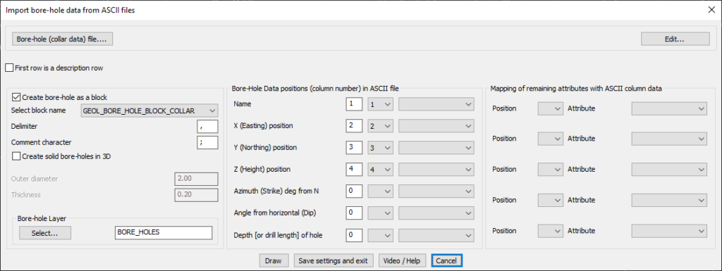
GeoTool -> Geological/Mining Tools -> Bore-Hole -> Import bore-hole data

Import Bore-Hole Data: GEOL_BOREHOLELOGGER – GeoTools Command

Import Bore-Hole Data: GEOL_BOREHOLELOGGER – GeoTools Command

Key Features Include:

  • Import Borehole Data from ASCII Files:
    • Load borehole collar data from a structured ASCII file.
    • Supports multiple column delimiters (e.g., comma, semicolon) for data parsing.
    • Option to mark the first row as a description header for clarity.
  • Borehole Representation in CAD:
    • Create boreholes as blocks using predefined GEOL_BORE_HOLE_BLOCK_COLLAR symbols.
    • Option to generate solid boreholes in 3D with adjustable outer diameter and thickness.
    • Assign boreholes to a specific CAD layer (e.g., BORE_HOLES).
  • Customizable Data Mapping:
    • Assign column numbers for:
      • Borehole Name
      • X (Easting), Y (Northing), and Z (Height) positions
      • Azimuth (Strike) and Dip (Angle from Horizontal)
      • Depth (or drill length) of the borehole
  • Flexible Attribute Mapping:
    • Map additional custom attributes from ASCII columns for advanced borehole analysis.
  • Efficient Workflow Options:
    • Draw boreholes in CAD immediately.
    • Save settings and exit for future data imports.

Benefits:

This tool is essential for exploration geology, mineral resource estimation, and geotechnical site investigations, ensuring precise borehole placement and data management in CAD environments.

Leave a Comment

Your email address will not be published. Required fields are marked *