Summary
The GT_PTINTERAUTOMATIC command in GeoTools is used to automatically assign elevation values to points by interpolating from neighboring polylines or 3D faces based on existing surface data. This tool is particularly beneficial for terrain modeling, topographical mapping, and digital elevation model (DEM) creation in BricsCAD, AutoCAD, ZWCAD and ARES Commander.
GeoTool -> Build Tools -> Build Tools -> Interpolate point elevation from neighboring polylines – automatic
Key Features Include:
- Automated Elevation Interpolation:
- Scans surface data layers to determine elevation values for selected points.
- Interpolates between adjacent 3D polylines, 3D faces, or DEM datasets.
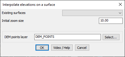
- Dynamic Search with Adjustable Zoom Levels:
- Starts with a user-defined zoom size and increases incrementally if surface data isn’t found within the initial search range.
- Ensures accurate interpolation even for large terrains or sparse datasets.
- Selection of Surface Data for Interpolation:
- Displays a list of available surfaces saved in the drawing.
- Requires surfaces to be stored in a predefined format (Surface<Surface_Name>).
- If surface data is missing, it can be imported using GT_IMPORTSURFACE.
- DEM Layer Integration:
- Allows users to define a specific layer for DEM points, ensuring organized elevation data storage.
Benefits:
- Automates the process of elevation assignment, reducing manual effort.
- Ensures accurate and reliable interpolation for survey and GIS applications.
- Improves terrain modeling by seamlessly integrating point elevations with surface data.
- Enhances 3D visualization and analysis for topographic and civil engineering projects.
This tool is essential for surveyors, GIS professionals, and CAD users working on topographical modeling, elevation mapping, and 3D terrain analysis.