Summary
The GT_CONTLABEL command allows users to annotate contour polylines with elevation values, custom text, or curve length. This tool is essential for professionals working in topographic mapping, civil engineering, and GIS applications where clear labeling of contour data is required.
GeoTool -> Annotation Tools -> Annotation Tools -> Label contour polylines
Label Contour Polylines: GT_CONTLABEL – GeoTools Command
Key Features Include:
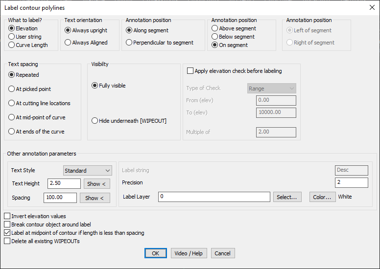
What to Label?
- Elevation: Labels the contour with its elevation value.
- User String: Allows custom text annotation along the polyline.
- Curve Length: Annotates the total length of the polyline.
Text Orientation:
- Always Upright: Ensures text remains readable, automatically flipping when necessary.
- Always Aligned: Keeps text aligned with the contour, even if inverted.
Annotation Position:
- Along Segment: Text follows the direction of the contour segment.
- Perpendicular to Segment: Text is placed perpendicular to the contour.
- Above, Below, or On the Segment: Controls vertical placement of the label.
- Left or Right of Segment: Applicable when using perpendicular placement.
Text Spacing Options:
- Repeated: Labels are placed at specified intervals along the contour.
- At Picked Point: Allows manual selection of label placement.
- At Cutting Line Locations: Labels where a defined line intersects the contour.
- At Midpoint of Curve: Places annotation at the curve’s midpoint.
- At Ends of the Curve: Labels the start and end points of the contour.
Visibility Options:
- Fully Visible: Labels appear without masking.
- Hide Underneath (WIPEOUT): Labels are placed with a WIPEOUT background to hide contour lines underneath, improving readability.
Elevation Check Before Labeling:
- Enables conditional labeling based on contour elevations:
- Range: Labels only contours within a specified elevation range.
- Multiples of a Value: Labels only specific contour intervals (e.g., every 10m contour).
Other Annotation Parameters:
- Text Style: Choose a font style for annotation.
- Text Height & Spacing: Customize label size and distance between labels.
- Label Layer & Color Selection: Assign specific layers and colors for contour labels.
- Invert Elevation Values: Flip positive and negative elevation values.
- Break Contour Object Around Label: Creates a gap in the contour line for better visibility.
- Delete Existing WIPEOUTs: Clears previously applied WIPEOUT masks for cleanup.
Benefits:
- Improves readability of contour maps by providing clear, well-placed labels.
- Customizable positioning ensures labels fit within any map layout.
- Automates elevation annotation, reducing manual drafting effort.
- Supports various text orientations and spacing methods to suit different use cases.
- Works seamlessly in BricsCAD, AutoCAD, ZWCAD and ARES Commander.
The GT_CONTLABEL command is a powerful, flexible tool for contour labeling, making CAD-based topographic and GIS workflows more efficient and professional.