Summary
The GT_IDXYZ command is used to label selected points with their X, Y, Z coordinates in various formats. This tool is highly useful for surveying, GIS, topographic mapping, and engineering applications where precise coordinate annotation is required.
GeoTool -> Annotation Tools -> Annotation Tools -> Label points
Label Points: GT_IDXYZ – GeoTools Command
Key Features Include:
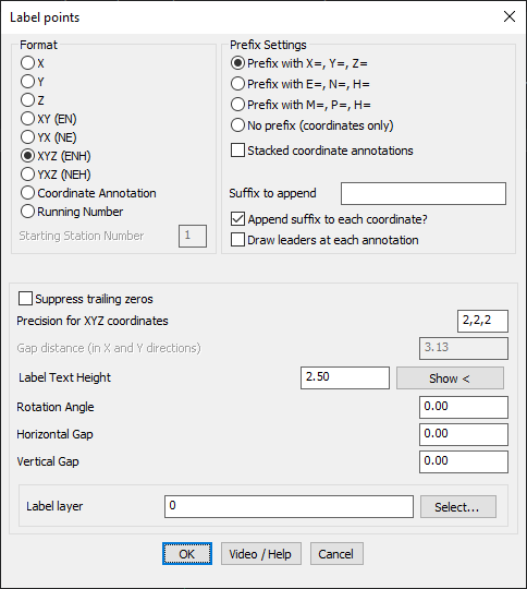
Format Options for Labels:
- X, Y, Z: Labels only the respective coordinate.
- XY (EN) & YX (NE): Labels both X and Y values in different orderings.
- XYZ (ENH), XYZ (NEH): Includes X, Y, and Z values with different formatting styles.
- Coordinate Annotation: Allows custom labeling of coordinate values.
- Running Number: Assigns a sequential number to each labeled point, useful for indexing survey data.
Prefix Settings:
- Prefix with X=, Y=, Z= (or E=, N=, H= for Easting/Northing notation).
- Custom prefix (M=, P=, H=) available for specific mapping conventions.
- No prefix option: Labels coordinates directly without prefixes.
Text Formatting & Display Options:
- Suppress Trailing Zeros: Prevents unnecessary decimal places in the labels.
- Precision Control: Customize decimal precision for X, Y, and Z separately (e.g., 2,2,2 for two decimal places).
- Gap Distance: Sets spacing for stacked coordinate annotations in X and Y directions.
- Label Text Height: Adjustable for different drawing scales.
- Rotation Angle, Horizontal & Vertical Gap: Fine-tunes text placement for clarity.
Additional Annotation Options:
- Append Suffix to Each Coordinate: Allows adding custom text after coordinate values.
- Draw Leaders at Each Annotation: Improves readability by connecting labels to their respective points.
- Stacked Coordinate Annotations: Enables vertical formatting of X, Y, and Z values for compact display.
Layer Management:
- Label Layer Selection: Assign labels to a specific CAD layer for better organization.
Benefits:
- Automates the process of coordinate labeling, saving time in manual annotation.
- Highly customizable to fit various engineering, surveying, and GIS standards.
- Supports multiple coordinate formatting conventions, including Easting/Northing.
- Ensures accuracy with precision control and formatting options.
- Seamlessly integrates with BricsCAD, AutoCAD, ZWCAD and ARES Commander.
The GT_IDXYZ command is a powerful, flexible tool for coordinate labeling, making CAD-based surveying and mapping workflows more efficient and professional.