Summary
The GT_VXLABEL command enables precise labeling of vertices in polylines, lines, 3D faces, and splines. It provides various annotation options for coordinate values, elevations, distances, and numbering, making it an essential tool for CAD users working on topographic, survey, and infrastructure drawings
GeoTool -> Annotation Tools -> Annotation Tools -> Label polyline vertices
Label Polyline Vertices: GT_VXLABEL – GeoTools Command
Key Features Include:
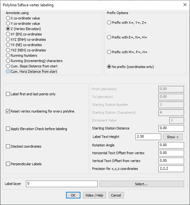
Annotation Options:
- X Coordinate Value: Labels each vertex with its X-coordinate.
- Y Coordinate Value: Labels each vertex with its Y-coordinate.
- Z (Vertex Elevation): Displays elevation values at each vertex.
- XY (Easting-Northing) Coordinates: Shows both X and Y coordinates for each vertex.
- XYZ Coordinates: Displays complete 3D coordinate values at each vertex.
- Running Numbering: Assigns a sequential number to each vertex, useful for tracking.
- Cumulative Slope Distance: Computes and labels the total slope distance from the first vertex.
- Cumulative Horizontal Distance: Computes and labels the total horizontal distance from the first vertex.
Label Formatting & Customization:
- Prefix Options: Choose from X=, Y=, Z=, E=, N=, H=, or custom prefixes for different notation styles.
- Label First and Last Points Only: Reduces clutter by placing labels only at the start and end vertices.
- Vertex Number Reset for Each Polyline: Ensures numbering starts from a defined value for every polyline.
- Elevation Range Filtering: Labels only vertices within a specified elevation range.
- Precision Control: Independently define decimal precision for X, Y, and Z values.
- Text Placement Adjustments: Set horizontal and vertical offsets from the vertex position for better visibility.
Advanced Settings:
- Station Numbering: Assigns a starting station number for labeling, useful for sequential polyline labeling.
- Station Distance Customization: Adjusts starting station distance for cumulative distance-based labels.
- Label Rotation & Alignment: Customize text height, rotation angle, and offset for optimal readability.
Benefits:
- Automates vertex labeling, reducing manual effort and errors.
- Provides detailed coordinate, elevation, and distance data for GIS, topography, and surveying.
- Improves clarity and readability of CAD drawings with customizable label positioning.
- Ideal for infrastructure, road alignment, and geospatial applications.
- Fully compatible with BricsCAD, AutoCAD, ZWCAD, and ARES Commander.
The GT_VXLABEL tool simplifies complex labeling tasks, making it faster, more accurate, and highly configurable for any CAD-based mapping or design workflow.