Summary
The GT_NODELINESNAP command in GeoTools is designed for cleaning up linear and point feature data, correcting undershoot and overshoot errors by snapping line vertices and point objects to nearby features in BricsCAD, AutoCAD, ZWCAD and ARES Commander.
GeoTool -> Drawing Cleanup Tools -> Drawing Cleanup Tools -> Linear and Node Snap (MAGNET)
Linear and Node Snap (MAGNET): GT_NODELINESNAP – GeoTools Command
Linear and Node Snap (MAGNET): GT_NODELINESNAP – GeoTools Command
Key Features Include:
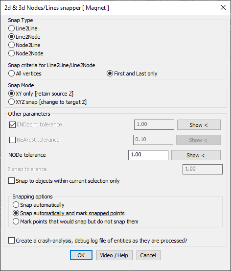
- Snap Type Selection:
- Line2Line – Snaps line vertices to another line.
- Line2Node – Snaps line vertices to nearby point objects.
- Node2Line – Snaps point objects to nearby lines.
- Node2Node – Snaps point objects to other points.
- Snap Criteria for Line2Line / Line2Node:
- All Vertices – Considers all polyline vertices for snapping.
- First and Last Only – Restricts snapping to only the endpoints of lines.
- Snap Modes:
- XY Only – Retains the original Z elevation while snapping in XY plane.
- XYZ Snap – Adjusts the Z elevation to match the snapped target object.
- Tolerance Controls:
- ENDpoint Tolerance – Specifies a range within which a vertex is snapped to the closest endpoint.
- NEArest Tolerance – If endpoint snapping fails, the nearest available point within tolerance is used.
- NODE Tolerance – Defines how close a point feature must be to another node for snapping.
- Z Snap Tolerance – Ensures that only points within a defined Z-difference are considered for snapping.
- Snap Options:
- Snap Automatically – Snaps points and lines immediately.
- Snap & Mark Snapped Points – Snaps and marks modified points for verification.
- Mark Points Only – Identifies potential snaps but does not modify the drawing.
- Restrict Snapping to Current Selection:
- Ensures that snapping only occurs within selected objects, preventing unintended modifications elsewhere in the drawing.
Benefits:
This tool is particularly useful for GIS data cleanup, surveying, and CAD drafting, ensuring topological accuracy and consistency by eliminating overshoots and undershoots in linework.