Summary
The GT_INTEX command in GeoTools processes intersecting polylines, allowing users to either break (split) polylines at intersections or add vertices at intersection points in BricsCAD, AutoCAD, ZWCAD and ARES Commander.
GeoTool -> Drawing Cleanup Tools -> Drawing Cleanup Tools -> Lineworks Intersections Processor
Lineworks Intersections Processor: GT_INTEX – GeoTools Command
Lineworks Intersections Processor: GT_INTEX – GeoTools Command
Lineworks Intersections Processor: GT_INTEX – GeoTools Command
Lineworks Intersections Processor: GT_INTEX – GeoTools Command
Key Features Include:
- Intersection Processing for Polylines:
- Works with both 2D and 3D polylines containing linear segments only (no splines, fits, or arcs).
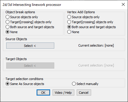
- Object Break Options:
- Source Objects Only – Breaks only the selected source polylines at intersections.
- Target (Crossing) Objects Only – Breaks only the target polylines where they intersect with the source objects.
- Both Source and Target Objects – Breaks both source and target objects at intersections.
- None – No objects are broken, but vertices can still be added at intersections.
- Vertex Addition Options:
- Source Objects Only – Adds a vertex at intersections on source polylines only.
- Target (Crossing) Objects Only – Adds a vertex at intersections on target polylines only.
- Both Source and Target Objects – Adds vertices to both source and target polylines at intersections.
- None – No vertices are added.
- Selection Control:
- Define Source Objects for processing.
- Define Target Objects for intersections (optional).
- Choose whether target objects are the same as source objects or selected manually.
Important Considerations:
- Works only on polylines (2D and 3D) with linear segments (not splined, fitted, or arc-based).
- If 3D polylines are used, ensure both source and target objects are in 3D to maintain correct interpolation.
Benefits:
This tool is essential for network mapping, road design, parcel subdivision, and utility planning, ensuring precise handling of linework intersections.