Summary
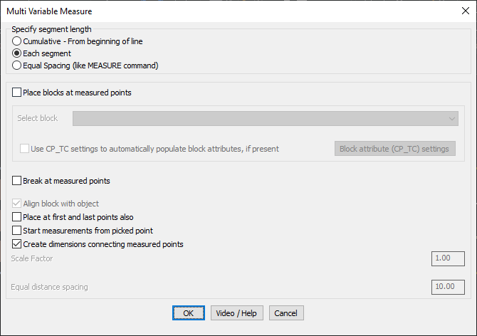
The GT_MVMEASURE command in GeoTools enables precise measurement and marking of variable distances along lines, polylines, and splines, offering flexibility beyond standard CAD measurement tools. It allows cumulative, segment-based, or equal spacing measurements and includes options for placing blocks, breaking polylines, and creating dimensions in BricsCAD, AutoCAD, ZWCAD and ARES Commander.
GeoTool -> Build Tools -> Build Tools -> Multi-Variable Measure
Key Features Include:
- Flexible Segment Length Measurement:
- Cumulative – From Beginning of Line: Measures and marks distances progressively from the start of the line.
- Each Segment: Measures distances relative to the previous segment.
- Equal Spacing (Like MEASURE Command): Creates equidistant markers along the line while allowing extra customization such as block scale control and placement at the start and end points.
- Block Placement and Alignment:
- Allows users to place a block at each measured point, selecting from blocks available in the current drawing.
- Option to align blocks with the object’s slope, ensuring proper orientation.
- Polyline Modifications at Measured Points:
- Break at Measured Points: Splits the polyline at the defined distances.
- Place at First and Last Points: Ensures a block or point is added at both endpoints.
- Automatic Dimensioning:
- Creates dimensions connecting the measured points, making it easier to visualize the distances directly on the drawing.
- Customization Options:
- Scale Factor Control: Adjusts the inserted block size for better visibility.
- Start Measurements from Picked Point: Allows defining a custom start location for measurement instead of the polyline’s default start.
Benefits:
- Provides more control and flexibility compared to standard MEASURE or DIVIDE commands.
- Enhances surveying, engineering, and road design workflows by allowing customized measurement intervals.
- Improves drawing clarity and readability with automatically inserted dimensions and markers.
- Saves time by automating repetitive measurement tasks, ensuring accuracy and consistency.
This tool is essential for surveyors, civil engineers, and CAD professionals working on road networks, pipelines, or any design requiring precise distance-based markings.