Summary
The GT_CROSSSECT command in GeoTools is a powerful tool for generating cross-sectional profiles across a terrain model at defined intervals. This command is particularly useful for volume computations, earthwork analysis, and terrain modeling in BricsCAD, AutoCAD, ZWCAD and ARES Commander.
GeoTool -> Geological/Mining Tools -> General -> Multiple Cross Section Tools
Multiple Cross Section Tools: GT_CROSSSECT – GeoTools Command
Key Features Include:
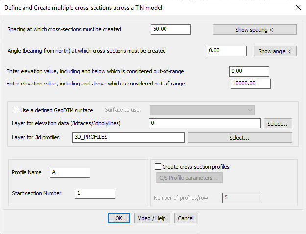
- Automated Cross-Section Generation:
- Define the spacing at which cross-sections must be created.
- Set the angle (bearing from north) for cross-section alignment.
- Elevation Range Control:
- Specify minimum and maximum elevation limits to filter out-of-range data.
- Surface Data Integration:
- Option to use a GeoDTM surface for elevation data.
- Assign layers for 3D faces, 3D polylines, and cross-section profiles.
- Customizable Profile Settings:
- Set profile name and starting section number for organized data management.
- Define the number of profiles per row for structured visualization.
- Cross-Section Profiling:
- Option to automatically create cross-section profiles, aiding in terrain volume calculations.
Benefits:
The GT_CROSSSECT command combines multiple GeoTools functions like GT_DRAPEPOLY, GT_SET_Z_PL, and GT_PROFILE to streamline cross-section creation and volume estimation. By generating terrain cross-sections, it enables accurate area calculations, which, when multiplied by section width, provide precise volume estimations for earthwork projects.
This tool is ideal for roadway design, riverbed analysis, excavation planning, and land development projects, offering efficient and automated cross-section profiling.