Summary
The GEOL_PLACEDIPSTRIKESYMBOL command in GeoTools allows users to place dip and strike symbols for geological mapping and analysis. This tool is essential for structural geologists, mining engineers, and GIS professionals working in BricsCAD, AutoCAD, ZWCAD and ARES Commander.
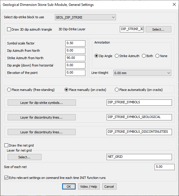
GeoTool -> Geological/Mining Tools -> Dimensional Stone -> Place dip/strike symbols
Key Features Include:
- Customizable Dip-Strike Symbol Placement:
- Use predefined dip-strike blocks (e.g., GEOL_DIP_STRIKE).
- Option to draw a 3D dip azimuth triangle for enhanced visualization.
- Assign symbols to a dedicated 3D dip-strike layer (e.g., DIP_STRIKE_3C).
- Precise Geological Data Input:
- Define dip azimuth from north, strike azimuth, and dip angle from horizontal.
- Set the elevation of the point for accurate geological modeling.
- Adjustable symbol scale factor for better visibility.
- Flexible Annotation Options:
- Display dip angle, strike azimuth, both, or none as annotation.
- Set line-weight for clarity in geological drawings.
- Multiple Symbol Placement Methods:
- Manual Placement (Free-standing) – Place symbols anywhere in the drawing.
- Manual Placement on Cracks – Manually position symbols along mapped fractures.
- Automatic Placement on Cracks – Automatically distribute symbols along crack features.
- Layer Management for Geological Features:
- Assign layers for dip-strike symbols (e.g., DIP_STRIKE_SYMBOLS).
- Separate layers for geological discontinuity lines and fault structures.
- Grid Display & Additional Features:
- Option to draw a net grid for structural analysis.
- Specify grid size and assign to a dedicated layer (e.g., NET_GRID).
- Command line echoing for real-time tracking of input parameters.
Benefits:
With GEOL_3POINT, users can efficiently analyze geological formations, ensuring accurate orientation measurements for geospatial and engineering applications.