Summary
The GT_NETNODES command in GeoTools is designed to systematically place nodes (points) along a connected linear network of lines and polylines. This command is particularly useful for network-based spatial analysis, utility mapping, and transportation planning, where nodes need to be placed at regular intervals along a predefined route.
GeoTool -> Build Tools -> Build Tools -> Place points along linear network
Key Features Include:
Node Placement Along Network Paths:
- Nodes are placed at a specified distance interval along the network, ensuring even spacing based on the path’s geometry.
- Unlike a straight-line distance calculation, this tool follows the actual polyline network to measure node placement.
Topological Accuracy Requirement:
- The command works best when the network is topologically correct, cleaned, and has perfectly touching endpoints between lines.
- Any gaps or misaligned endpoints in the network could lead to inaccurate node placement.
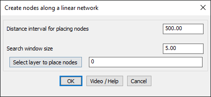
Configurable Parameters for Precision Control:
- Distance Interval for Placing Nodes: Defines the spacing between nodes along the network.
- Search Window Size: Determines how far the tool should look for connected lines at each step, ensuring it correctly follows the network.
- Layer Selection for Nodes: Users can specify the layer where the placed nodes should be stored.
Benefits:
Benefits:
- Ideal for transportation and utility networks (road junctions, water distribution points, power line poles).
- Supports GIS applications, ensuring structured node placement for further network analysis.
- Enhances spatial accuracy by placing nodes at true network distances, not just Euclidean straight-line distances.
- Useful in routing applications, coverage analysis, and infrastructure mapping.
This tool is valuable for surveyors, GIS professionals, and urban planners dealing with network-based spatial data processing in BricsCAD, AutoCAD, ZWCAD and ARES Commander.