Summary
The GT_ROUGHEN command in GeoTools allows users to roughen a linear object (line or polyline) by introducing random zig-zag patterns along its length. This tool is particularly useful for topographic representation, geological mapping, and artistic rendering in BricsCAD, AutoCAD, ZWCAD and ARES Commander.
GeoTool -> Miscellaneous Tools -> Miscellaneous Tools -> Roughen a Line
Key Features Include:
- Roughen Any Linear Object:
- Works on both lines and polylines.
- Generates randomized zig-zags on either side of the original line.
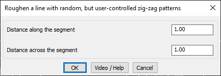
- User-Controlled Parameters:
- Define distance along the segment to control zig-zag frequency.
- Set distance across the segment to adjust the zig-zag amplitude.
- Randomized & Naturalistic Patterns:
- Ensures a non-uniform, organic appearance, making it ideal for:
- Geological fault lines
- Terrain and erosion representation
- Artistic sketch effects in CAD drawings
- Ensures a non-uniform, organic appearance, making it ideal for:
Benefits:
This tool is useful for geologists, cartographers, landscape designers, and CAD drafters who need irregular, natural-looking linework in their CAD environments.