Summary
The GT_SCALE_Z command in GeoTools updates 2D polylines, 3D polylines, and 3D faces by scaling the Z-values of each vertex using a specified factor in BricsCAD, AutoCAD, ZWCAD and ARES Commander.
GeoTool -> Conversion Tools -> Conversion Tools -> Scale Z values
Key Features Include:
- Applies Z-Scaling to Multiple Object Types:
- Works on 2D polylines, 3D polylines, and 3D faces.
- Supports Z scaling for POINTs, BLOCKs, and SHAPEs.
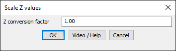
- Customizable Z Conversion Factor:
- Users can increase or decrease elevation values by specifying a scale factor.
- A factor greater than 1 increases Z-values, while a factor less than 1 reduces them.
- Preserves Geometry Integrity:
- Ensures that only the Z-values are modified while retaining XY coordinates.
Benefits:
This tool is essential for terrain modeling, elevation adjustments, and CAD-based 3D transformations, providing precise control over vertical scaling in drawings.