Summary
The GT_SET_Z_PL command in GeoTools adjusts out-of-range elevation values in polylines by replacing them with the nearest valid non-zero elevation. This ensures a consistent elevation profile in BricsCAD, AutoCAD, ZWCAD and ARES Commander.
GeoTool -> Drawing Cleanup Tools -> Drawing Cleanup Tools -> Set out-of-range elevation values to nearest valid elevation values
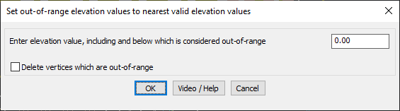
Set Out of Range Elevation Values to Nearest Valid Elevation Values: GT_SET_Z_PL – GeoTools Command
Key Features Include:
- Corrects Out-of-Range Elevation Values:
- Scans polyline vertices and identifies those with elevations equal to or below a specified threshold.
- Replaces these values with the nearest non-zero vertex elevation.
- User-Defined Elevation Threshold:
- Allows users to specify a custom elevation value, treating any vertex at or below this value as out-of-range.
- Option to Delete Out-of-Range Vertices:
- Provides the ability to remove invalid vertices instead of adjusting them.
Benefits:
- Ensures smooth and accurate elevation transitions in polyline data.
- Eliminates zero or out-of-range elevation values, improving terrain modeling and topographical accuracy.
- Helps in cleaning up surveyed data where incorrect elevations might exist.
- Improves 3D visualization and analysis by maintaining a consistent elevation profile.
This tool is particularly useful for surveying, civil engineering, and GIS applications, ensuring that polyline elevation data remains reliable and free of errors.