Summary
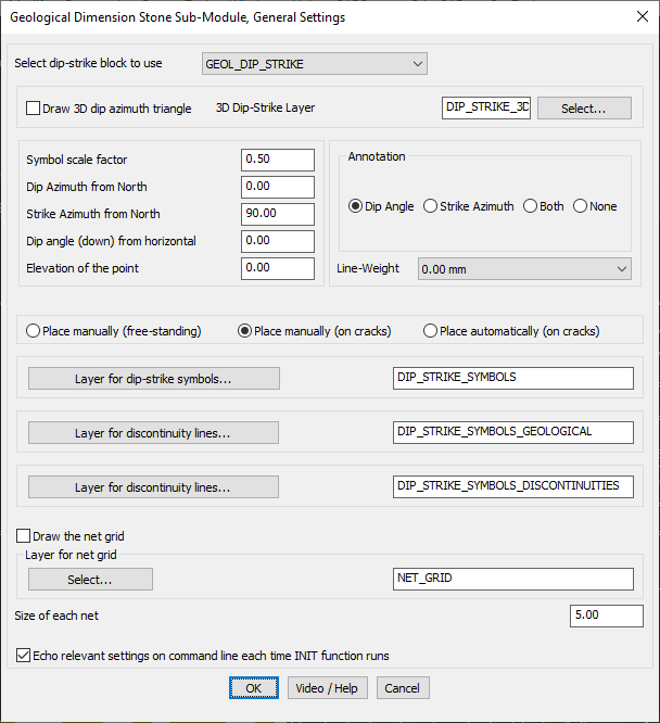
The GEOL_DIMSTONE_SETTINGS command in GeoTools provides a comprehensive settings panel for configuring dip and strike symbols, geological discontinuities, and net grids. This tool is essential for geologists, mining engineers, and GIS professionals working with dimension stone deposits in BricsCAD, AutoCAD, ZWCAD and ARES Commander.
GeoTool -> Geological/Mining Tools -> Dimensional Stone -> Settings
Key Features Include:
- Dip-Strike Symbol Configuration:
- Select a predefined dip-strike block (e.g., GEOL_DIP_STRIKE).
- Option to draw 3D dip azimuth triangles for enhanced visualization.
- Assign dip-strike symbols to a specific CAD layer (e.g., DIP_STRIKE_3C).
- Customizable Geological Data Inputs:
- Define dip azimuth from north, strike azimuth, and dip angle from the horizontal plane.
- Set the symbol scale factor and elevation of points for 3D representation.
- Annotation & Visualization Controls:
- Display dip angle, strike azimuth, both, or none as annotations.
- Adjustable line-weight for clear and precise geological drawings.
- Symbol Placement Options:
- Manual Placement (Free-standing) – Manually place symbols at any location.
- Manual Placement on Cracks – Position symbols directly on detected fractures.
- Automatic Placement on Cracks – Automate symbol placement along cracks.
- Layer Management for Geological Features:
- Assign dedicated layers for:
- Dip-strike symbols (e.g., DIP_STRIKE_SYMBOLS)
- Geological discontinuity lines (e.g., DIP_STRIKE_SYMBOLS_GEOLOGICAL)
- Fault and discontinuity mapping (e.g., DIP_STRIKE_SYMBOLS_DISCONTINUITIES)
- Assign dedicated layers for:
- Grid Overlay for Structural Analysis:
- Option to draw a net grid to assist in geological structure analysis.
- Define the grid size and assign it to a specified CAD layer (e.g., NET_GRID).
- Command Line Echoing:
- Displays relevant settings on the command line whenever the INIT function runs.
Benefits:
This tool is essential for dimension stone mapping, fracture analysis, and geological structural interpretation, allowing for accurate visualization and documentation in CAD environments.