Customize Consent Preferences

We use cookies to help you navigate efficiently and perform certain functions. You will find detailed information about all cookies under each consent category below.

The cookies that are categorized as "Necessary" are stored on your browser as they are essential for enabling the basic functionalities of the site. ... 

Always Active

Necessary cookies are required to enable the basic features of this site, such as providing secure log-in or adjusting your consent preferences. These cookies do not store any personally identifiable data.

No cookies to display.

Functional cookies help perform certain functionalities like sharing the content of the website on social media platforms, collecting feedback, and other third-party features.

No cookies to display.

Analytical cookies are used to understand how visitors interact with the website. These cookies help provide information on metrics such as the number of visitors, bounce rate, traffic source, etc.

No cookies to display.

Performance cookies are used to understand and analyze the key performance indexes of the website which helps in delivering a better user experience for the visitors.

No cookies to display.

Advertisement cookies are used to provide visitors with customized advertisements based on the pages you visited previously and to analyze the effectiveness of the ad campaigns.

No cookies to display.

GeoTools

Specify and Plan Mining Lease Area Data: GEOL_LEASEAREAPLANNER – GeoTools Command

Summary

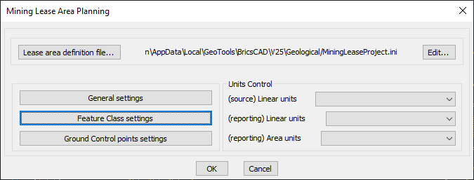
The GEOL_LEASEAREAPLANNER command in GeoTools is designed for planning and managing mining lease areas, enabling precise specification of lease boundaries, feature classes, and control points. This tool is essential for mining engineers, land surveyors, and GIS professionals working in BricsCAD, AutoCAD, ZWCAD and ARES Commander.

GeoTool -> Geological/Mining Tools -> General -> Specify and plan mining lease area data

Specify and Plan Mining Lease Area Data: GEOL_LEASEAREAPLANNER – GeoTools Command

Key Features Include:

  • Lease Area Definition & Configuration:
    • Load and edit lease area definition files (*.INI format) for structured planning.
    • Configure general settings, feature classes, and control points.
  • Feature Class Customization:
    • Define different land-use and geological classifications for mining areas.
    • Assign specific layers, colors, and symbols to each feature class.
  • Ground Control Points Management:
    • Set reference points for lease boundary accuracy.
    • Essential for survey alignment and regulatory mapping.
  • Units Control for Reporting & Analysis:
    • Specify source linear units (meters, feet, etc.).
    • Customize reporting units for linear and area measurements.

Benefits:

This tool is particularly useful for mine planning, regulatory approvals, and lease documentation, ensuring compliance with industry standards and mapping accuracy.

Leave a Comment

Your email address will not be published. Required fields are marked *