Summary
The GT_SLOPEDISTWEED command in GeoTools enables users to remove unnecessary vertices from 3D polylines based on slope and distance criteria. This enhances polyline efficiency and accuracy within BricsCAD, AutoCAD, ZWCAD and ARES Commander.
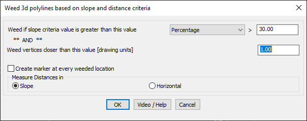
GeoTool -> Polyline Tools -> Vertex Management -> Weed (remove) vertices based in 3D slope and distance
Key Features Include:
- Dual Criteria for Vertex Weeding:
- Slope-Based Filtering: Removes vertices if the slope between consecutive points exceeds a specified percentage or ratio.
- Distance-Based Filtering: Eliminates vertices that are closer than a defined distance in drawing units.
- Customizable Slope Measurement:
- Choose between percentage or ratio for slope evaluation.
- Measure Distances in:
- Slope Distance – Measures along the actual 3D path.
- Horizontal Distance – Measures the projected distance on the XY plane.
- Create Marker for Weeded Vertices:
- Option to place POINT objects at removed vertex locations for verification.
- Optimizes 3D Polyline Data:
- Ideal for topographical mapping, contour line refinement, road grading, and terrain modeling, ensuring smooth and efficient 3D polylines.
Benefits:
This tool is essential for civil engineers, surveyors, and GIS professionals working with 3D terrain and elevation-sensitive designs.