Customize Consent Preferences

We use cookies to help you navigate efficiently and perform certain functions. You will find detailed information about all cookies under each consent category below.

The cookies that are categorized as "Necessary" are stored on your browser as they are essential for enabling the basic functionalities of the site. ... 

Always Active

Necessary cookies are required to enable the basic features of this site, such as providing secure log-in or adjusting your consent preferences. These cookies do not store any personally identifiable data.

No cookies to display.

Functional cookies help perform certain functionalities like sharing the content of the website on social media platforms, collecting feedback, and other third-party features.

No cookies to display.

Analytical cookies are used to understand how visitors interact with the website. These cookies help provide information on metrics such as the number of visitors, bounce rate, traffic source, etc.

No cookies to display.

Performance cookies are used to understand and analyze the key performance indexes of the website which helps in delivering a better user experience for the visitors.

No cookies to display.

Advertisement cookies are used to provide visitors with customized advertisements based on the pages you visited previously and to analyze the effectiveness of the ad campaigns.

No cookies to display.

GeoTools

Weed (Remove) Vertices Based on Distance and Angle: GT_DistAngWeed – GeoTools Command

Summary

The GT_DISTANGWEED command in GeoTools helps simplify polylines by removing redundant vertices based on distance, deflection angle, or a combination of both. This ensures optimized polyline geometry in BricsCAD, AutoCAD, ZWCAD and ARES Commander.

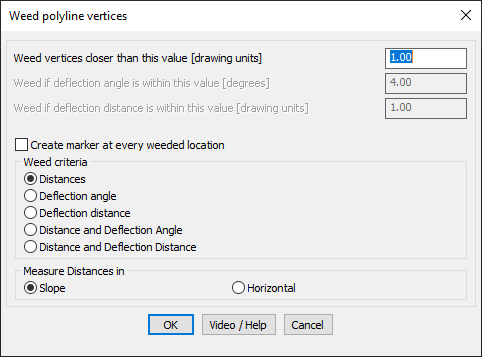
GeoTool -> Polyline Tools -> Vertex Management -> Weed (remove) vertices based on distance and angle

Weed (Remove) Vertices Based on Distance and Angle: GT_DistAngWeed – GeoTools Command

Key Features Include:

  • Vertex Weeding Criteria:
    • By Distance – Removes vertices that are closer than a specified distance.
    • By Deflection Angle – Removes vertices where the deflection angle is within a specified threshold.
    • By Deflection Distance – Eliminates unnecessary vertices based on deviation from a straight path.
    • Combination Methods – Weeding based on both distance & deflection angle or distance & deflection distance for better optimization.
  • Create Marker for Weeded Locations:
    • Option to place a POINT object at each removed vertex for verification.
  • Distance Measurement Options:
    • Slope Distance – Measures actual 3D distances.
    • Horizontal Distance – Measures the projected horizontal distances.
  • Processing Limitations:
    • Arc Segments Handling – Works on straight-line distances of polyline segments, not true arc distances. Use GT_PLARC2PL to convert arc polylines into segmented polylines for better results.

Benefits:

This tool is highly useful for surveying, GIS applications, civil engineering, and road alignment design, where unnecessary vertices can be removed while maintaining polyline accuracy.

Leave a Comment

Your email address will not be published. Required fields are marked *