Introduces Object Table Data Plus More+++ with GeoTools-CADPower V 20.03
Bengaluru, India

We are pleased to announce to you the release of V 20.03 of GeoTools and CADPower today which brings to the users a major new feature that is useful to all users across industry segments.
CADPower Object Table Data (also available in GeoTools) is based internally on extended entity data and offers a complete interface to create an object table (similar to the AutoCAD Map Object Table), attach and detach data from entities and edit the same using a convenient interface.
There is also a tool to export the data to CSV files and a Query tool also is planned in the coming version.
With these set of tools, you can easily turn your .dwg file into a database of sorts, and tag every entity to underlying attached data.
The following new commands are available in V 20.03 as part of this functionality:
(new command) CP_DATAMAN / GT_DATAMAN:
CP_DATAMAN @ CADPower -> Build -> CADPower Object Data -> Data Manager
GT_DATAMAN @ GeoTools -> Build -> GeoTools Object Data -> Data Manager
This command is brand new and offers all tools for object table definition creation & editing.
Here, you can create a new object data table, add fields and specify their types and set default values. The user interface of this command is simple and self-descriptive.
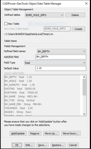
In the first version released in V 20.03, the following object data field types are support : Integer, Real and String.
In the next update, two more field types: Point and (hyper)Link-URL will be supported.
(new command) CP_ATTACHDATA / GT_ATTACHDATA:
CP_ATTACHDATA @ CADPower -> Build -> CADPower Object Data -> Attach Data
GT_ATTACHDATA @ GeoTools -> Build -> GeoTools Object Data -> Attach Data
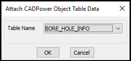
This command allows object data tables to be attached to selected entities.
The default values for the fields as specified during the table creation will be copied and set during this process.
(new command) CP_DETACHDATA / GT_DETACHDATA:
CP_DETACHDATA @ CADPower -> Build -> CADPower Object Data -> Detach Data
GT_DETACHDATA @ GeoTools -> Build -> GeoTools Object Data -> Detach Data
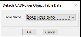
This command allows object data tables to be detached from selected entities.
(new command) CP_EDITDATA / GT_EDITDATA:
CP_EDITDATA @ CADPower -> Build -> CADPower Object Data -> Edit Data
GT_EDITDATA @ GeoTools -> Build -> GeoTools Object Data -> Edit Data
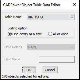
This command allows object data to be edited. If multiple objects are selected, you are presented with the above dialog box and you can edit the object data in two ways:
One entity at a time: Clicking this option brings up the object data editor for each entity separately and you can edit the values manually.
All at once: Clicking this option allows you to set a specified object data value and the same will be applied to all selected entities.
CP_CPOD_EXPORT / GT_CPOD_EXPORT:
CP_CPOD_EXPORT @ CADPower -> Build -> CADPower Object Data -> Export Data
GT_CPOD_EXPORT @ GeoTools -> Build -> GeoTools Object Data -> Export Data
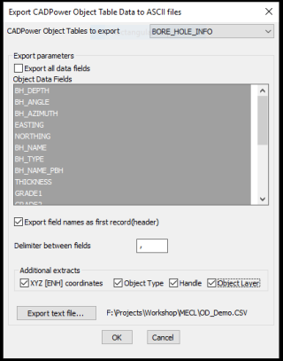
The CP_CPOD_EXPORT command allows to export the selected fields of an object table data to a CSV file.
The delimiter in the file can be specified and additional exports like XYZ coordinates, object type, handle and object layer can be exported as well.
In the next version, we will include the ability to import the data exported by CP_CPOD_EXPORT and update the data inside the CAD platform.
This will function on similar lines of the ATTIN / ATTOUT command of AutoCAD but here, it applies to just about any entity.
The ability to attach data to entities is far-reaching and many existing CADPower and GeoTools command have started to take advantage of the same.
The following list of commands have been updated to use the new data linking feature.
(new command) CP_BOUNDARY / GT_BOUNDARY:
CP_BOUNDARY @ CADPower -> Build -> Create a boundary (closed polygon) around a point
GT_BOUNDARY @ GeoTools -> Build -> Create a boundary (closed polygon) around a point
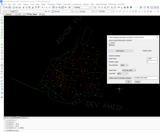
The CP_BOUNDARY & GT_BOUNDARY is a new command added in both GeoTools and CADPower to create a closed polyline boundary around a selected point.
A point (or block) is also created at the centroid of the newly created polygon. This is a useful tool to build topology in mapping and space planning operations.
It is also possible to compute the area of the bounding polygon and store the same attached to the centroid as a block attribute or as object table data.
(updated/enhanced command) GT_CCPOLY:
GT_CCPOLY @ GeoTools -> Build -> Create closed polylines from a mass of networked polylines
GT_CCPOLY is also a topology-building tool, somewhat similar to the GT_BOUNDARY command.
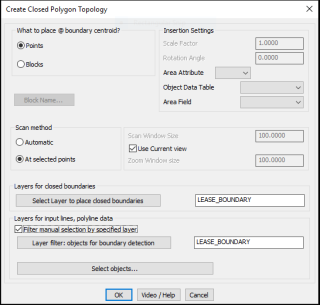
This command has been significantly improved and expanded. It is now possible to store the area of the closed polyline created as a block attribute or as GeoTools Object data. The tools for object selection and layer filtering have been improved.
(updated/enhanced command) CP_TILEPLACE
CADPower -> BOM/BOQ Tools -> Place tiles / XY sized panels
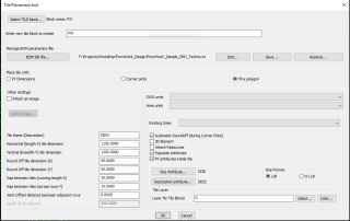
The CP_TILEPLACE command has been significantly improved. This is part of our ongoing improvements to make CADPower a useful for the space planning, form-work design and drafting, and fabrication / panel sizing applications.
The following improvements have been made:
- A drop-down menu for ‘Existing Sizes’ of the current tile block has been added. With this, you can easily know the various tile sizes you have used so far in the current drawing and also re-insert them quickly without having to re-enter the With and Breadth of the tile.
- When the ‘Corner Picks’ option was chosen to create the tiles, the command would fail if too small a window was chosen and it would inadvertently update the previously placed block. This has been fixed now.
- An option for ‘Size Format’ has been added. It is now possible to create the tile as 1000 x 600 or add a W in front and write it as W1000 X 600. This is in line with the requirement of some of our existing users.
- An option to create the SIZE and DESC attributes of the block as Fitted text or Normal Middle Centered text has been added. The option to not use Fitted attributes ensures that the attribute remains readable at all scales. The option to Fit it ensures that the attribute stays inside the block. The choice is yours.
(updated/enhanced command): CP_FACENORMAL
CADPower -> Miscellaneous -> CAD Procedures -> Second Set -> Control 3DFace normals
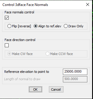
The CP_FACENORMAL command is a tool to manage the face normals of a 3DFACE object.
In surface modeling, it is often important to know or set the direction of the face normal, especially for rendering purposes.
The CP_FACENORMAL command visually draws the normal of 3dface objects to a given length or makes the face normal of a selection of 3dfaces to point in a particular direction based on a reference elevation.
This command has been significantly improved and bug-fixed.
GT_TRIANGULATE /GT_VORONOI
GeoTools -> Civil Tools -> Create TIN (Delauney triangulation) & Voronoi polygons
The GT_TRIANGULATE command has been improved significantly. The Voronoi polygon drawing capability of this command has been strengthened and the following new options have been added.
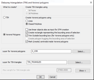
The GT_TRIANGULATE / GT_VORONOI command dialog box
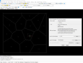
Voronoi polygons – after trim and centroidal correction
- It is now possible to create a closed polyline hugging the area of the points selected for Delauney triangulation.
- Under Voronoi polygons, it is now possible to trim completely outside the bounding box polyline that covers the area of the Voronoi polygons.
- The Voronoi points are not necessarily at the centroidal location of the polygon they represent. It is now possible to create them at the exact centroidal location also.
- The Voronoi polygons can be created a closed polylines or as independent lines. This feature has been bug-fixed and works correctly now.
For BricsCAD in India, Contact DesignSense
CADPower V20 for BricsCAD: EXE (-or-) ZIP (Linux/Mac compatible)
CADPower V20 for AutoCAD: EXE (-or-) ZIP
GeoTools V20 for BricsCAD: EXE (-or-) ZIP (Linux/Mac compatible)
GeoTools V20 for AutoCAD: EXE (-or-) ZIP
BricsCAD V19: Trial download
BricsCAD V19 Shape: Free download
BricsCAD Communicator V19: Trial download
Key Contacts: rakesh.rao(at)thedesignsense.com / +91-9243438300 / +91-8073279755
Follow us on Twitter: https://www.twitter.com/rakesh_rao
Key Contacts: rakesh.rao(at)thedesignsense.com / +91-9243438300 / +91-8073279755
Follow us on Twitter: https://www.twitter.com/rakesh_rao
