Presenting V18 release and 18.01 update of GeoTools and CADPower
Bengaluru, India

V18 starts with a big leap in geological and mining tools
It is that time of the year when, many years back, we used to wait eagerly for the next numbered major release of AutoCAD software!
We still do, not because AutoCAD has something new to offer in its release, but because it is also the time we up-shift GeoTools and CADPower software to the next numbered release of AutoCAD.
The timing is relevant only to the extent that our AutoCAD subscription clients find it useful to upgrade to the new GeoTools-CADPower along with AutoCAD.
For the rest, it is only a matter of upgrading GeoTools while still using an older AutoCAD.
V18 of GeoTools & CADPower continues to maintain compatibility with AutoCAD versions 2018, all the way down until 2007.
And that is an incredible 11 versions of AutoCAD, and of course, 4 versions of BricsCAD as well.
We present V 18.0 release and 18.01 update of GeoTools & CADPower, and all that is new in this release so far.
Strengthening the Mining, Geology & Civil tools continues to dominate our priorities and focus in GeoTools development.
This will remain one of our thrust areas in the V18 life-cycle as well.
Remember that the mining tools are evolving with each update of GeoTools.
Rather than wait until the most complete version is ready, we will release usable chunks of the software with each minor update.
With regular feedback and interaction from users, we fine-tune, bug-fix, enhance and improve the tools as we go along.
We start off V18 with a bunch of new tools that have been added to make mining data processing easier.
New command added: GEOL_BOREHOLEPLANNER (GeoTools -> Mining & Geological Tools -> Bore-hole sections planner [across lease area]):

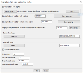
The GEOL_BOREHOLEPLANNER command is the first process command to use when you start mineral exploration and design.
Once your base-map is available and mining lease area defined, you can use this command to create bore-hole section lines across the mining lease area (closed boundary) at user defined intervals along and across the area.
Bore-holes are then drawn as dynamic blocks (named BORE_HOLE_BLOCK) along the section line at each vertex point.
It has a visibility state that defines its quality pictorially. The following states can be set:
- Default
- Problematic Quality
- Blue
- Positive
- Negative
Please note that these visibility states are defined as per the requirements of the dimensional stone industry and is not necessarily the most appropriate set of conditions for other mining industry.
If you have your inputs and feedback about what you would like to see as other visibility states, please do get in touch with me with your inputs.
We have room to cater to multiple industry segments.
In addition, the block has the following attributes:
- X – Easting (X) coordinate of the bore-hole location
- Y – Northing (Y) coordinate of the bore-hole location
- Z – Elevation (Z) coordinate of the bore-hole location
- NAME – Bore-hole ID or name
- QUALITY – Quality of the bore-hole yield
- DEPTH – Depth to which it has been drilled
- DIP – The dip angle of the bore hole
- STRIKE – The strike angle of the bore hole
This command will fill the lease area with bore-hole sections and create bore hole blocks along the sections.
You can also optionally export the data to a CSV file which can be edited within the command itself.
The bore-hole sections, bore-holes and other data are represented in their own layers.
Enhanced command GEOL_RUNNINGPATTERNS: (Menu: GeoTools -> Mining & Geological Tools -> Create topo/geological running patterns):

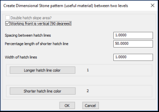
The GEOL_RUNNINGPATTERNS command has been improved. A new option added to the dimensional stone annotations (useful materials).
Normally, you need two faces of the rock to create the slope annotations between.
In the case of useful material annotations, there is now an option to specify whether the working front is vertical.
If this option is chosen, the pattern is drawn with only one side and a specified width of pattern.
New command added: GEOL_BOREHOLEBIGGER (GeoTools -> Mining & Geological Tools -> Make bore-hole size bigger):
Increases the size of the bore-hole 10% each time. The bore-holes are read automatically from the designated layer.
With a command that is designed in this way, you do not need to remember the text height of the bore gole attributes. Simply make it bigger or smaller by 10% each time.
New command added: GEOL_BOREHOLESMALLER (GeoTools -> Mining & Geological Tools -> Make bore-hole size smaller):
Decreases the size of the bore-hole 10% each time. The bore-holes are read automatically from the designated layer.
With a command that is designed in this way, you do not need to remember the text height of the bore gole attributes. Simply make it bigger or smaller by 10% each time.
New command added: GEOL_BOREHOLETEXTSMALLER (GeoTools -> Mining & Geological Tools -> Make bore-hole text smaller):
Decreases the size of the bore-hole text 10% each time. The bore-holes are read automatically from the designated layer.
New command added: GEOL_BOREHOLETEXTBIGGER (GeoTools -> Mining & Geological Tools -> Make bore-hole text bigger):
Increases the size of the bore-hole text 10% each time. The bore-holes are read automatically from the designated layer.
New command added: GEOL_BOREHOLEINSERT (GeoTools -> Mining & Geological Tools -> Insert bore-hole along a section):
The GEOL_BOREHOLEINSERT command allows you to pick a bore-hole section polyline and inserts a new bore-hole point along the section or near it. This command internally calls the CADPower CP_INSVX command and you can first insert a point (or more points) along the section.
After the new polyline points are created, the bore-hole block is automatically inserted at the location with the default set of attributes.
New command added: GEOL_BOREHOLESECTIONRENAME (GeoTools -> Mining & Geological Tools -> Rename a bore-hole section):
The GEOL_BOREHOLESECTIONRENAME command renames a section and all bore-holes along the section.
New command added: GEOL_MAKE3DSECTIONS (GeoTools -> Mining & Geological Tools -> Create 3d bore-hole sections): The GEOL_MAKE3DSECTIONS command is used to drape the bore-hole section (assumed to be 2D) along the contours or DTM and create a 3d section out of it.
Internally, the command uses the GT_DRAPEPOLY functionality to build the 3d profile across the section line. The elevations are extracted from the points where the section line crosses a contour or a DTM object (like 3dface or 3d polyline) and then interpolates the bore-hole elevation which lies between two known non-zero elevations from the neighborhood. In other words, this tool applies the GT_PL_INTER command as well, in addition to GT_DRAPEPOLY.
(At the time of this writing, this command is still partially in development, partially complete and is in beta)
New command added: GEOL_BOREHOLEEXPORT (GeoTools -> Mining & Geological Tools -> Bore-hole export to CSV): The GEOL_BOREHOLEEXPORT command allows you to select bore hole sections or bore-hole blocks and exports them into a CSV file with pre-determined
New command added: ID_GEOL_BOREHOLESECTIONDELETE (GeoTools -> Mining & Geological Tools -> Delete bore-hole sections): The GEOL_BOREHOLESECTIONDELETE command is used to delete bore-hole sections from the drawing. When you pick a section polyline and delete it, all the bore-holes associated with that section also are automatically deleted.
Enhanced command GT_ASN_PROP: The GT_ASN_PROP command has been bug-fixed and improved considerably.
The earlier version was designed to only work with 3d polylines and would compulsorily search for elevation objects around every vertex of the polyline.
We realized this was not practical and extended the inherit functionality to 2d polylines also. Further, the search can be performed around every vertex (suitable for 3d polylines) or near the ends (first and last point) of 2d polylines.
If you have 2d contour polylines (all with 0.0 elevations) and nearby text objects representing the contour elevation, it is now a breeze to assign contour elevations to such polylines.
** Misleading message removed: GeoTools & CADPower automatically run a startup lisp (if found) called CP_STARTUP.LSP / GT_STARTUP.LSP.
Due to a bug, there was a misleading error message each time that the file could not be found. This message has been removed.
** Wildcard search added in CP_VIDEOS, CP_BRICSYSTV and CP_MAINTENANCE commands in CADPower and GT_VIDEOS command in GeoTools:
While using these commands, it is now enough to simply type the string you want to search (in the filter window).
It is not necessary to add an asterisk ‘*’ character to denote a wildcard search. It is now automatic.
