Insert a GeoTagged photo using GeoTools V14
Bangalore, India
GT_INSPHOTO
Important note: If you need more information about this command or detect a malfunction in this command, please email me immediately : rakesh.rao(at)4d-technologies.com
Yet another new command in GeoTools V14 in the GeoTools->Geographic menu (GT_INSPHOTO) allows a geo-tagged photo to be attached to your CAD drawing.
Geo-Tagging is a method by which geographical position info is attached to a normal photo image (JPG, PNG, GIF etc) as a meta data, such that the location (latitude and longitude) where the photo was taken is stored along with the image file.
Such a capability is now common-place with smart phones and tablets which have built-in GPS capabilities.
It is also possible to geo-tag a photograph using many of the higher end cameras in the market today.
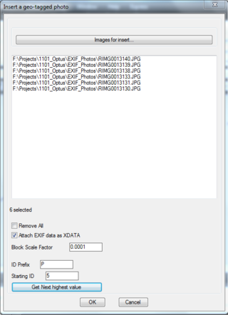
Using the GT_INSPHOTO command, you can select a geo-tagged photo and it will get inserted in your drawing at the correct Lat-Long coordinates.
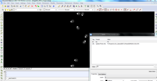
Of course, the inserted object is a block by name PHOTO-CIRCLE and it has attributes called ID and URL.
The ID is a running number and the URL is the location of the image file on the disk.
The image location is also tagged as a hyper-link to the block such that a Ctrl-Click on the block opens the attached image.
The GT_INSPHOTO is a great tool to import your geo-tagged images into CAD for subsequent export into a KML file using the GT_DWG2KML command.

You can select multiple image files for import, a starting ID, an ID prefix and also determine the next highest available ID in your drawing.
\The EXIF data from the images can also be saved optionally as xdata attached to the objects so that they can be further exported into a KML file is necessary or used by other programs, or using the GT_DWG2KML function in GeoTools.

The above screen-shot shows how each photo block is inserted in CAD with the correct angle of rotation (orientation) as per the GPSIMGDIRECTION attribute from the EXIF data of the photos.
This command is available both in BricsCAD and AutoCAD versions of GeoToools.


