CADPower-GeoTools V 16.01 Update
Bengaluru, India
We released GeoTools-CADPower V16 last week. During the life-cycle of this release, we promise to deliver a number of fixes and enhancements to ensure that you have a predictable user experience running our software under all environments and versions of supported CAD platform.
Here is the first of our update V 16.01:
GeoTools V 16.01, What’s New?
GT_SLOPEDISPLAY – GeoTools -> Civil Tools -> Color-coded slope display of TIN faces:
This tool color codes 3d polygons based on their slope values.
The default slope values in percentages was limited to a range from 0% to 100% (45 degrees slope).
This resulted in not being able to display slopes greater than 45 degrees. This has been fixed.
The slope ranges have now been increased to 2000% which is a 87 degree slope, perhaps the maximum you can encounter in real life.
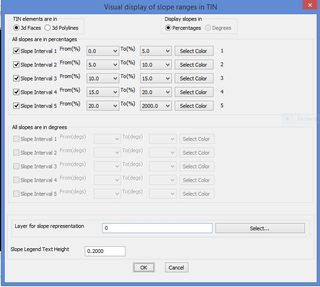
A new option to display slopes in degrees is being developed, and is expected to be available in V 16.02
CP_IDXYZ: CADPower -> Annotation -> Label points:
This tool labels picked points with coordinates and running numbers using a variety of different formats.
Choosing ‘Coordinate Annotation’ as the annotation format caused the Prefix/Suffix options to be grayed out. This has been fixed.
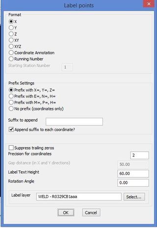
The offset distances for ‘Coordinate Annotation’ is now defaulted as 1.25 times the text height.
This gives a properly spaced annotation in Easting and Northing.
Earlier, the user had to make sure to set a proper spacing, failing which the annotations would overlap and look ugly.
Additionally, a small red temporary square marker is now added for all point annotations picked on a blank area. This provides a visual cue about the point picked.
GT_CCPOLY: GeoTools -> Build -> Create closed polylines from a mass of networked polylines:
Purpose: This tool helps in topology building by creating closed polygon boundaries from a mass of lines representing various disconnected edges.
Polygon edges selected was shown in the dialog box as a line item but not remembered in the layer dialog.
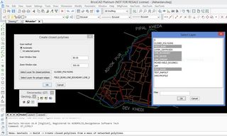
This has been fixed now.
GT_CROSSSECT: GeoTools -> Civil Tools -> Multiple Cross Section Tools:
The layer for ‘TIN Triangles’ and ‘3dprofiles’ selection are not updating correctly.
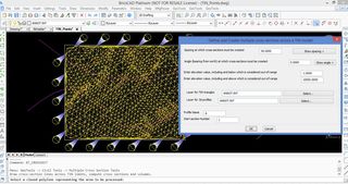
This has been fixed now.
GT_LENTEXT: GeoTools -> Annotation -> Create/update length annotation:
The dialog box settings were not saved in memory for the next session until the command completed its operation.
This has now been fixed. Upon exit from the ‘Settings’ dialog box with an ‘Ok’, the settings are immediately saved in the registry.
GT_PROFILE: GeoTools -> Civil Tools -> Draw cross-sectional profile from 3D Polyline
A number of changes have been made to this command based on user feedback.
- Chainage output file format changed to CSV to facilitate easy export to Excel. A comma is now used as a delimiter (instead of fixed field length space delimiters earlier) for the same reason.
- The chainage output file format has changed slightly. A new field called ‘SerialNumber’ has been added to track count of the records. The ‘Height’ field has been moved to the end, after Easting and Northing.
- Incorrect profile layer classification bug fixed.
CP_CGRID: CADPower -> Draw -> Geometry -> Construction Grid
The grid lines, labels and the baloon circle now can be created in their own layers instead of everything being on the current layer.
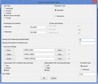
The CP_CGRID command dialog box resized and the height has been reduced. This enables the dialog to display correctly under all display resolutions.
CP_TC: CADPower-> Text-> Creation-> Draw Quick Text (running numbers)
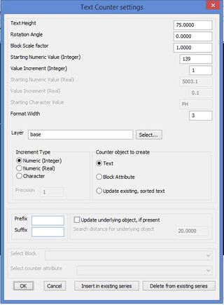
The CP_TC command dialog box resized and the height has been reduced. This enables the dialog to display correctly under all display resolutions.
– Minor improvements and fixes in readme file and messages
GT_CHAINAGE: GeoTools -> Civil Tools -> Annotate chainages along a route
Improvements have been made in this command. The entire chainage data information is now written to CSV file which can import into Excel directly.
CP_INSVX: CADPower-> Polyline-> Vertex Management-> Insert Vertex

A red color temporary marker is displayed where the vertex was created.
CP_ROUGHEN: CADPower -> Draw -> Symbology -> Roughen a line
The CP_ROUGHEN was crashing in BricsCAD Classic. This has been fixed now.
This command was generating a closed roughened polyline even if the original object was open. This has been fixed now.
CP_MODTXT : CADPower -> Text -> Editing -> Globally modify TEXT/MTEXT
If the ‘Set Value’ or ‘Trim characters’ option of this command results in an empty string, the text in question now gets deleted and does not result in a null-text entity. This results in a cleaner drawing with no phantom text objects.
Changes to the CADPower macros:
- S (SCRIPT) has been removed. S now defaults to STRETCH
- D (DIST) has been removed, D now defaults to DIM
- LA (LAYER) command-line version has been removed, now defaults to the dialog version
Direct download links:
Download GeoTools V16 for AutoCAD: English, Spanish, German
Download GeoTools V16 for BricsCAD: English, Spanish, German
Download CADPower V16 for AutoCAD: English, Spanish, German
Download CADPower V16 for BricsCAD: English, Spanish, German
Follow us on Twitter: http://www.twitter.com/rakesh_rao
