
CADPower-GeoTools V24.17 Update Draw/Split GIS Polygons Manage Concentric Circles
CADPower-GeoTools V24.17 Update Draw/Split GIS Polygons Manage Concentric Circles
CADPower-GeoTools V24.17 Update Draw/Split GIS Polygons Manage Concentric Circles
CP_SHEETCUTTER (CADPower -> BOM/BOQ Tools -> Panels, Layout & Sizing -> Cut a rectangular sheet with gap allowance)
CP_SHEETCUTTERARTITRARY (CADPower -> BOM/BOQ Tools -> Panels, Layout & Sizing -> Cut an artibrary shaped sheet with gap allowance)
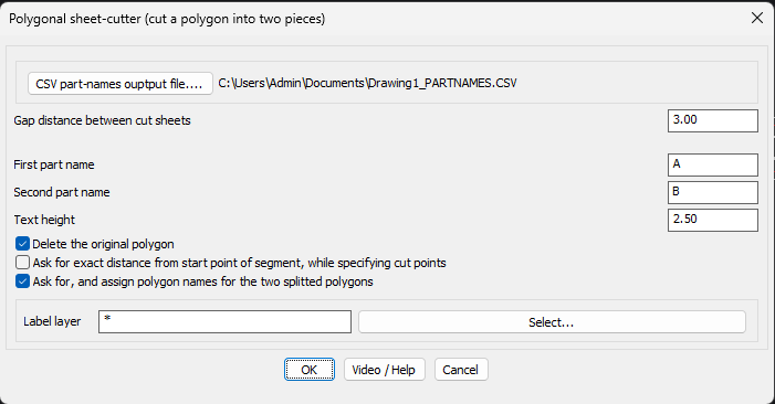
The CP_SHEETCUTTER and CP_SHEETCUTTERARBITRARY commands have been improved. You can now type ‘S’ in response to the first prompt and bring up this dialog-box where you can specify the operating parameters easily.
All the operating parameters of this command is now laid out clearly making it easier for the user to know what the command does.
There is an option to automatically delete the original polygon once the split is done.
There is also an option now to make the program ask (optionally) for an exact distance (from the edge) where the cut is made. This allows better control of the output.
It is often common to have a text inside the sheet that contains its part name. You can ask this command to look for the polygon (sheet) name from within the polygon and assign it to the newly splitted polygon.
If there are no existing sheet names found within, you can enter the names for the two splitted sheets in the dialog box.
Gap distance between the polygon cuts: Specify the gap to be maintained between the two polygons. If you want the two polygons to be flush (touching exactly) with each other, specify the gap as 0.0.
First part name / Second part name: Specify the names of the two parts of the polygon formed after the split. If there are no existing polygon names found inside, the values specified here are assigned to the newly formed split polygons.
Delete the original polygon: Specifies whether the original polygon is retained or deleted after the split.
Ask for exact distance from start point of segment, while specifying cut points: While specifying the cut points for the polygon, you can specify the exact distance from the nearest vertex point. This is enabled by clicking this option. If the option is not clicked, the point that you click with your mouse will be taken as the first and second points of cut for the polygon. For example, if you want the cut point of the polygon at an exact distance of 10.0 from one of the vertex points, you can fine-tune this measurement by using this option. While exercising this option, you will see a small square marker which indicates the nearest vertex point, so that you get a visual indication of the same.
Search for, and assign polygon names fro the two splitted polygons: If you enable this option, you can search the specified layer(s) for any existing text which represents the polygon name, and the same will be used to assign the names to the two splitted polygons.
CP_CONCENTRIC (CADPower -> Miscellaneous -> CAD Procedures -> Second Set -> Manage concentric circles)
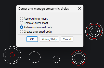
The CP_CONCENTRIC command manages concentric circles and edits them according to a specific rule. This command provides options to remove the outermost or innermost concentric circle, retain the outermost circle, or create an average-radius circle and remove the rest of the.
This command was inspired by the fabrication industry, where circles represent holes to be made on the base.
This command can also have many other uses. For example, we have seen field data collected with circles of different radius representing measurements of data at the same point for the same purpose. The average option of this command can help in this case.
GT_POLYGONCUTTER (GeoTools -> Build -> Cut a polygon into two using a slicing line)
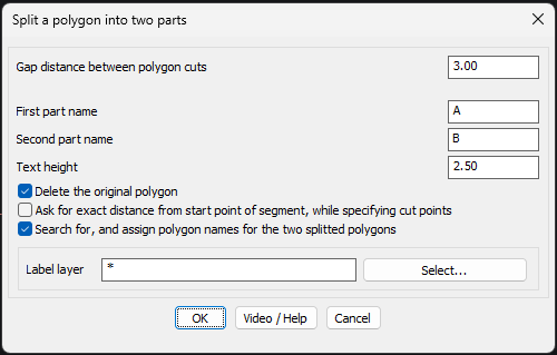
The GT_POLYGONCUTTER command is very similar to the CP_SHEETCUTTER command of CADPower, and combines the ability to split a polygon (regular and arbitrary) into two parts easily. This is often required in GIS and mapping projects. You can access the ‘Settings’ dialog of this command by typing ‘S’ in response to the first prompt which asks you to select the polygon to split.
While splitting, the gap between the two split polygons can be specified. Existing polygon names from within can be searched and carried forward to the new polygons.
If there are no existing polygon names found within, you can enter the names for the two polygons in the dialog box.
Gap distance between the polygon cuts: Specify the gap to be maintained between the two polygons. if you want the two polygons to be flush (touching exactly) with each other, specify the gap as 0.0. If you are creating property divisions, where the two polygons need to be separated by an easement or a road or path, this is where you can specify the gap value.
First part name / Second part name: Specify the names of the two parts of the polygon formed after the split. If there are no existing polygon names found inside, the values specified here are assigned to the newly formed split polygons.
Delete the original polygon: Specifies whether the original polygon is retained or deleted after the split.
Ask for exact distance from start point of segment, while specifying cut points: While specifying the cut points for the polygon, you can specify the exact distance from the nearest vertex point. This is enabled by clicking this option. If the option is not clicked, the point that you click with your mouse will be taken as the first and second points of cut for the polygon. For example, if you want the cut point of the polygon at an exact distance of 10.0 from one of the vertex points, you can fine-tune this measurement by using this option. While exercising this option, you will see a small square marker which indicates the nearest vertex point, so that you get a visual indication of the same.
Search for, and assign polygon names fro the two splitted polygons: If you enable this option, you can search the specified layer(s) for any existing text which represents the polygon name, and the same will be used to assign the names to the two splitted polygons.
GT_DRAWGISPOLYGON (GeoTools -> Draw -> Draw polygons (for mapping, GIS))
The GT_DRAWGISPOLYGON command in GeoTools has been born. This promises to be a useful tool to create building outline geometry that is often digitized from drone imagery, aerial photos and similar data sources.
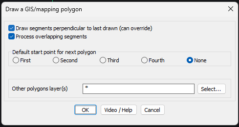
The ‘Settings’ dialog box contains a bunch of parameters that control how the digitization process works.
Drawing segments perpendicular to each other: Digitizing buildings is often done with orthogonal (right-angled) sides. This option can be set, but it can be easily overridden at each point input by simply pressing the F8 (ORTHOMODE) option on or off. When it is on, you can create building geometry easily where the walls of the building are perpendicular to each other.
Processing overlapping segments: When you create a new polygon that intersects an existing polygon, it is normally expected that there is either a union of the two polygons or a subtraction of one (mostly bigger) polygon from the other.
Default start point for the next polygon: When you digitize polygons, you do them one after the other, in succession. When you create the next polygon, where do you want the start point to be set as default? That is what you can control here. Run this command a few times, and you will realize what the First, Second, Third and Fourth points of the polygon are. You can set one of these points as the next default start point.
Other polygon layer(s): This specifies the layer(s) to look for when you are searching for other polygons to merge or intersect.