GeoTools and CADPower Now Available for BricsCAD V17
Bengaluru, India

CADPower and GeoTools have been updated to run on BricsCAD V17 now. You need to get V 17.13 which is the newest update released today which is compatible with BricsCAD V17.
If you have V 17.12 or below of CADPower and GeoTools, it will NOT run on BricsCAD V17.
CADPower V 17.13 Update
Enhancement: CP_VXLABEL: CADPower -> Annotation -> Label polyline vertices: While annotating polylines, the CP_VXLABEL command now displays the last point label with a description called [Perimeter] when using the ‘Cumulative Slope distance from start’ option. \
This enables to annotate vertices of a polyline with the distance from the start and add a [Perimeter] string description against the last item. Makes it more communicative.

Enhancement: CP_CGRAV: CADPower -> Inquiry -> Compute Center of Gravity: The CP_CGRAV command now accepts a 3DFACE object as input for finding the center of gravity.
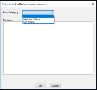
Enhancement: CP_SHOWPATHS (Menu: CADPower -> More Options -> Show system & DWG paths): The CP_SHOWPATHS command has been re-organized to make it more easier to use.

The command now offers a single dialog box which allows selecting ‘Windows folders’ and ‘CAD foldes’ from the same place.
Based on the selection, the list of folders is presented in the dialog box itself and can be selected and browsed through.
There is no need to type the folder ID numbers like before.
GeoTools V 17.13 Update
Enhancement: GT_POLYINSVX @ GeoTools -> Polyline Tools -> Process -> Polyline ‘Insert Vertex’ Tool: This command has been enhanced, and it is now possible to process multiple polylines together and have them inherit the elevations of nearby points and populate the Z values of their vertex elevations.
The option to select multiple polylines is not (yet) available from the main menu but can be exercised using a new command called GT_POLYINSVXSETTINGS.
The ability of this command to handle multiple polylines at once significantly improves the productivity factor by allowing large data-sets of polylines to acquire nearby elevation values from points.
Enhancement: GT_VXLABEL: GeoTools -> Annotation -> Label polyline vertices: While annotating polylines, the GT_VXLABEL command now displays the last point label with a description called [Perimeter] when using the ‘Cumulative Slope distance from start’ option.
This enables to annotate vertices of a polyline with the distance from the start and add a [Perimeter] string description against the last item. Makes it more communicative.
