GeoTools-CADPower V 16.19 Update
Bengaluru, India
CADPower V 16.19 Update
Enhanced command: CP_POLYAREACREATE (CADPower -> Draw -> Rule-Based -> Draw closed polylines to an exact area):
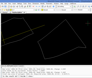
We introduced the CP_POLYAREACREATE command in V 16.14. Significant improvements have been made in this command following user inputs.
A new option has been added to specify the anchor point. This specifies the base point about which the scaling happens.
By default, the base point is set as the centroid of the polygon but it may not always be desired that way.
This new option helps to have finer control over the direction in which the scaling happens, and this is controlled by setting the anchor point.
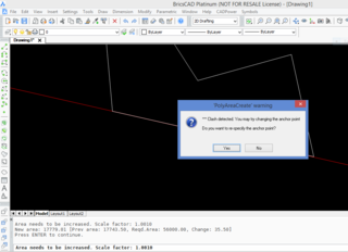
Additionally, a clash detection feature has been added.
If the polygon clashes with another line, polyline, arc or spline object as it scales up (or down), the program stops and issues an alert.
At this point, you have the option to change the anchor point and re-run the command.
GeoTools V 16.19 Update
Fixed command: GT_PL_DATALBL (GeoTools -> Annotation -> Label polylines with attached data):
The ‘Database’ link option to update data in this command has been removed from this version onwards.
We encountered several difficulties in supporting this option in the newer versions of AutoCAD and this was causing several crashes. This has now been removed and the GT_PL_DATALBL command now supports only object data and extended entity data linked labeling.
Enhanced command: GT_CROSSSECT (GeoTools -> Civil Tools -> Multiple Cross Section Tools):
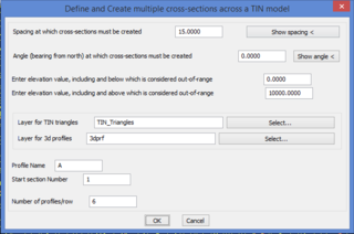
The ‘Multiple Cross-section tool’ GT_CROSSSECT has been enhanced. It now allows a single cross-section to be generated from a single picked 3d polyline.
The earlier option of creating multiple cross-sections also exists.
The results of the cross-sectional area calculation are now presented in a clearer format with color differentiation.
The sampling of the polyline for cross-sectioning is done based on the source vertex points now and this yields better accuracy of data.
Overall, the command has been made more robust and computational errors have been significantly reduced.
Enhanced command: GT_VOLUME (GeoTools -> Civil Tools -> Volume Calculation):
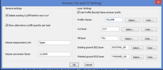
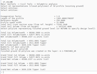
The GT_VOLUME command has been enhanced significantly. It takes an existing ground profile and a finished ground profile as inputs and computes the cut and fill volumes across the length of the profile.
The volume computation can now be reported in terms of number of cubic units or as a measure of the number of units of excavation through a vehicle or similar.
For example, if you have a tipper capable of carrying 12 cu.m of soil in each load, you can enter the ‘Volume measurement unit’ as ‘Tipper’ and the ‘Volume Conversion factor’ as 12.0.
The GT_VOLUME command can also create an updated 3d polyline that represents the finished ground level.
Since the existing ground profile is linked to the 3d polyline from which it was created, GT_VOLUME command creates an updated 3d polyline of finished ground polyline as well.
The layers for existing ground and finished ground are specified in the dialog box as shown above.
![]()
At the end of the computation, there is also a listing of the total area of fill and cut per section as well as for the entire area.
GeoTools announces a new section under Civil Tools called Road Design. The first one on this list is GT_CREATECARRIAGEWAY command
New command: GT_CREATECARRIAGEWAY (GeoTools -> Civil Tools -> Road Design -> Create road carriageway): The GT_CREATECARRIAGEWAY command is the first in our new series of road design tools.
It is a 3d visualization tool that also helps to build the 3d DTM of the road. You need to first have the finished road alignment created as a 3d polyline.
You can then define a closed 2d polyline as the cross-section of the road carriageway and it can be swept through the 3d alignment to create a 3d model of the road over the terrain.
This tool is still in beta mode and some of the rough edges need to be ironed out.
Internal enhancement: Many of CADPower and GeoTools commands use INI files to store their operating parameters and data.
The in-built INI editor tool had a bug in the ‘Duplicate’ record option which was causing the new record to display incorrectly in the wrong place. This has been fixed now.
A number of icons have been added & documentation updated.
