GeoTools-CADPower V 18.06, 18.07, 18.08, 18.09, 18.10 Update
Bengaluru, India
It has been a while since I wrote a post announcing the new releases of GeoTools and CADPower.
In this article, I bring to you a summary of all that we have been doing the past few weeks resulting in five updates of GeoTools and CADPower: V 18.06, V 18.07, V18.08, V18.09 and V18.10, the current as on date of this post.
This is a longish post and you can see our constant interaction with clients that use our products (on BricsCAD & AutoCAD) has inspired us and provided with many new ideas for productivity improvements to help make the CAD user’s life easier.
** New command added: CP_ANONYMOUSBLK (CADPower-> Blocks -> Block-related -> Convert to anonymous block):
The CP_ANONYMOUSBLK command can be used to create an anonymous block out of selected objects.
Anonymous blocks are internal blocks which don’t have a user-recognizable name but are nevertheless blocks for all purposes and can be used to create a grouping of objects.
Anonymous blocks are now recognized by our CP_BOM Quantity Estimation tool also. The anonymous blocks get an automatic name which looks like *Unn.
** Bug Fix: CP_VXLABEL (CADPower -> Annotation -> Label polyline vertices):
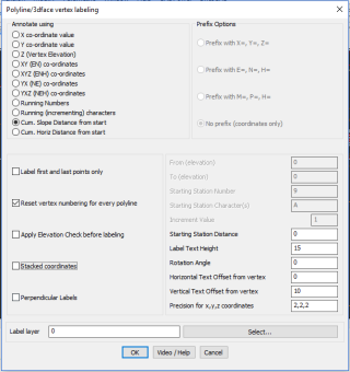
A bug has been fixed in this command. If the text offset position was set to any other value that 0.0 in X or Y, the ‘cumulative distance’ computation was wrong as the distance was computed to the offset point instead of the original. This has been fixed now.
** Bug fix & improvements: CADPower -> BOM/BOQ Tools -> Create Bill of Materials/Quantities:
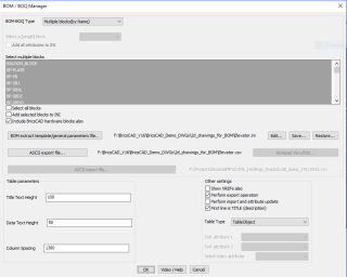
Fix: The [COMPOSITE_BLOCKS_SECTION] is now added by default in every INI file created or updated by CP_BOM. This was missing until now.
Improvement: The CP_BOM command now steps into every block and determines if there are embedded blocks within them.
If such blocks are found and if they are in the list of named blocks to process, they are included in the quantity computation as well.
This step makes it possible for a more accurate quantity computation in the case of drawing workflows where composite blocks containing sections of designs are common, and which are usually edited and managed using REFEDIT.
** Improvement: GT_CONTLABEL (GeoTools -> Annotation -> Label contour polylines):
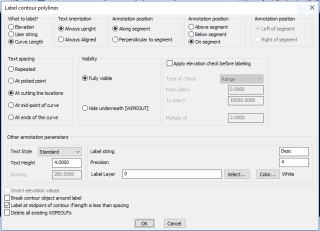
An option to set the precision of the contour labels has been added within the command itself. Until now, the precision was determined by the LUPREC linear units precision system variable.
** New command added: GT_ISLANDAREA (GeoTools -> Inquiry -> Island area detection):
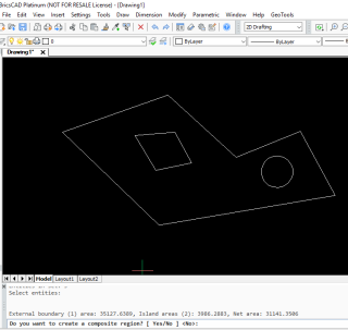
The GT_ISLANDAREA command returns the area of the largest closed polygon minus the area of all polygons found inside it.
It is a quick island area calculator command, which can scan only one level of embedded islands.
You need to ensure not select islands within islands -or- two sets of islands. The command assumes that you are working only with one set of island data.
** New (work in progress) command added: GEOL_AREAVOLCALC (GeoTools -> Mining & Geological Tools -> Area-Volume Calculation):
The GEOL_AREAVOLCALC command works on mine terrain cross-section data (in 2d) and computes the (soil) cut area required between the existing ground and the new finished ground (proposed bench profile).
You can also specify the intercepting mineral seams within the excavation and the area of the seams can also be computed.
These areas are exported as CSV files which can be combined on a section-by-section basis and the total volume (mine reserve estimates) can be computed.
The command is designed to work with three types of data:
- native Civil 3D data (custom objects)
- Civil 3D data converted to polylines
- normal CAD polylines created in plain AutoCAD/BricsCAD
If you are going to use native Civil 3D generated section data, this program assumes that the surfaces are named with some recognizable (searchable) names. They are asked during the run of this program.
For existing ground and finished ground, you need to enter the search criteria for surface names.
You can enter wildcards. For example if the pattern resembles ‘SLG-4 – SL-133 – Contours(757)’, you may enter ‘contours’ as the unique recognizable pattern.
If you are using native CAD data, the program will ask you for specific necessary data as you run this command.
The program can optionally export the output to a DWG via WBLOCK. If you are using AutoCAD Map, please be aware that there is bug which you need to know of.
There is an additional prompt that appears during WBLOCK ‘Include AutoCAD Map information in the output’. You need to manually click on ‘No’ at this prompt. There is no way it can be handled by program.
** Enhancement: GT_EMBHATCH (GeoTools -> Draw -> Draw Embankment hatch slopes pattern): The GT_EMBHATCH command has been enhanced to support 3D hatching.
The ‘Hatch as 3d’ option will additionally ask for elevations of the embankments and create the hatch lines in 3d. This helps in better visualization while annotating the terrain in a 3d context.
** Bug Fix: CP_XP_ATT ( CADPower -> Blocks -> Block-related -> Explode Block- Retain attributes as Text):
If the selected block has attributes which have been set with a null value (or defaulted or not set at all), the CP_XP_ATT command was creating a null text entity. This has been fixed now.
** New command added: CP_CRASHREPORTMGR (BricsCAD+ -> Support -> CrashReport Manager):
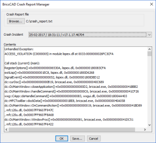
The CP_CRASHREPORTMGR command analyzes a BricsCAD crash report file ‘crash_report.txt’ and offers an incident-by-incident view of the report file, sorted as per the crash date & time.
Each incident report can then be saved separately into to sub-report file and used for further processing or send to support staff for necessary action.
Different users may face different proxy errors in BricsCAD. But we believe that many such errors can be fixed and it may have to be dealt with on a case-by-case basis.
If you are a BricsCAD user using an AutoCAD-generated proxy reference drawing, and have problems using the same in BricsCAD, please do let us know and we would be glad to assist you in finding a solution for the same.
** Enhancement: CP_INSVX ( CADPower-> Polyline-> Vertex Management-> Insert Vertex):
The CP_INSVX command has been updated and it is now possible to correctly interpolate the 3d elevation of the picked point during the Interactive mode (in case of 3d polylines).
The earlier version would place the vertex at the same elevation as its previous vertex.
** Enhancement: CP_ANGLABEL (CADPower -> Annotation -> Label Polyline Angles):
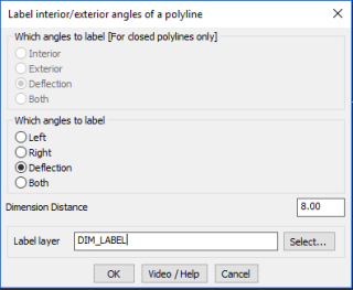
A new option called ‘Deflection Angle’ has been added. This creates an angular dimension annotation representing the deflection angle between the two segments of the polyline.
** New BricsCAD command added: CP_DWGSET (BricsCAD+ -> Support -> Drawing Settings):
The CP_DWGSET command provides a quick interface to some of the drawing settings that first time BricsCAD users most often want and find it difficult to find.
The current list of settings supported are:
- Sets the size (in pixels) of the entity selection target [1-50]
- Sets the size (in pixels) of the entity snap aperture box [1-50]
- Sets the size (in pixels) of the snap marker [1-50]
- Sets the cross-hair size as a percentage of the screen size [1-100]
- Enable right-click menu
- Enable middle button pan
- Create crash dump file
- Set Model/Paper Space background Color
Enhancement: CP_PL_STAT (CADPower-> Polyline Tools -> Inquiry Statistics -> Compute detailed polyline statistics):
GT_PL_STAT (GeoTools -> Polyline Tools -> Inquiry & Statistics -> Compute detailed polyline statistics):
The polyline statistics command has been enhanced significantly.
If a 2d polyline is selected, the segment slope information is now not displayed in the table and CSV output. It is now done only for 3d polylines. Earlier, a dummy 0.0%/degree slope was repeated for each segment.
The CSV reporting format has been improved for tidiness.
** New command added: CP_INSSIMILAR (Menu: CADPower-> Blocks -> Block-related -> Insert similar named blocks):
The CP_INSSIMILAR command inserts all blocks in the current drawing matching a given name pattern (wild-cards accepted) and places them next to each other on the drawing.
This is a useful maintenance and house-keeping command for your drawing when you have to manage multiple blocks belonging a the same or similar feature.
For example, if you have several *CHAIR* blocks in your drawing and want an easy way to view/edit and sorted them out, this tool helps.
** Enhancement: CP_MAINTENANCE (CADPower -> More Options -> Maintenance/Housekeeping):
The CP_MAINTENANCE command allows various CAD organization and Windows operating system related tasks to be performed from within the comforts of the CAD environment.
We have expanded the list significantly by providing quick access to a number of Windows tasks that are often required by users.
Here is the complete list of CAD tasks (including some for BricsCAD support) that you can launch from this command.
Please be aware that not all of them are implemented at the time of this writing. Run them to know which ones are already implemented and which ones are work in progress.
- CADPower: Create macro to switch off CADPower toolbars
- CADPower: Create macro to switch off GeoTools toolbars
- CADPower: Create macro to switch off CADPower & GeoTools toolbars
- Show Windows System path
- BricsCAD Setup/Organize: Show BricsCAD related Support folder path
- BricsCAD Setup/Organize: Overwrite default.cui with factory defaults
- BricsCAD Setup/Organize: Copy BricsCAD *.PAT files to specified location
- BricsCAD Setup/Organize: Copy BricsCAD *.LIN files to specified location
- BricsCAD Setup/Organize: Copy BricsCAD *.PAT files to install default location
- BricsCAD Setup/Organize: Copy BricsCAD *.LIN files to install default location
- BricsCAD Setup/Organize: Copy BricsCAD Drawing Templates to a specified location
- BricsCAD Setup/Organize: Copy BricsCAD Drawing Templates to install default location
- BricsCAD Setup/Organize: Copy BricsCAD Plot Styles to a specified location
- BricsCAD Setup/Organize: Copy BricsCAD Plotter Configuration to a specified location
- BricsCAD Setup/Organize: Set command prompt string
- BricsCAD Setup/Organize: Create an AutoCAD-like toolbar with common tools
- BricsCAD Setup/Organize: Check text for missing (replaced) fonts
- BricsCAD Setup/Organize: Copy BricsCAD default.cui file to specified location
- AutoCAD Setup/Organize: Copy AutoCAD *.PAT files to specified location
- AutoCAD Setup/Organize: Copy AutoCAD *.LIN files to specified location
- AutoCAD Setup/Organize: Copy AutoCAD Drawing Templates to a specified location
- AutoCAD Setup/Organize: Copy AutoCAD Plot Styles to a specified location
- AutoCAD Setup/Organize: Copy AutoCAD Plotter Configuration to a specified location
- BricsCAD licensing: Cannot connect to a network license server (error 17)
- BricsCAD licensing: How to migrate my license (up to V13) to another computer?
- BricsCAD licensing: How to try a higher features level (Pro or Platinum)?
- BricsCAD licensing: How can I see which license key is in use on a computer.
- BricsCAD licensing: Can’t connect to Bricsys License Activation Server (err:132/136)
- BricsCAD licensing: License Error Code 1024
- BricsCAD licensing: Windows Network License server setup help
- BricsCAD licensing: How do I setup my network license server on the same computer as license
- BricsCAD licensing: How to activate a single license or volume license
- BricsCAD licensing: How to configure the proxy server for license activation
- BricsCAD licensing: How to configure the proxy settings permanently for Network License use
- BricsCAD licensing: Manual License Activation procedure
- BricsCAD licensing: Error reading from network (error: 105)
- BricsCAD licensing: Manual license activation fails (error: 1007)
- BricsCAD licensing: How to revoke an activation after system crash?
- BricsCAD licensing: Display the local computer network server administration
- BricsCAD licensing: Unknown error – 1030
- BricsCAD licensing: License Error code 1024
- BricsCAD licensing: How to move a network license to another server?
- BricsCAD licensing: Error in http transaction with Activation server.
Here is the complete list of Windows tasks that you can launch from your CAD software:
- Windows Services: services.msc
- Windows Remote Desktop Connection: mstsc
- Windows System information: msinfo32
- Windows Backup and Restore: sdclt
- Windows Computer Management: compmgmt.msc
- Windows Disk cleanup utility: cleanmgr
- Windows Event viewer: eventvwr.nsc
- Windows Control Panel: control
- Microsoft Management Console: mmc
- Windows System resource monitor: resmon
- Windows – Change screen resolution: desk.cpl
- Take snap-shot using sniping tool: taskmgr
- Windows Task Manager: taskmgr
- Windows Mouse properties: main.cpl
- Problem Steps Recorder: psr
- Start Chrome broswer: chrome
- Start Firefox browser: firefox
- Windows Action Center: wcui.cpl
- Add/Remove programs: appwiz.cpl
This command works perfectly in AutoCAD, BricsCAD Pro and Platinum and with some restrictions in BricsCAD Classic.
The restrictions will be removed after the next update of BricsCAD Lisp engine, and will be applicable after the said update.
** Enhancement: CP_COMPUTEWALLAREAS (CADPower -> BOM/BOQ Tools -> Compute Wall/Openings areas): The CP_COMPUTEWALLAREAS command has been updated. You can now create separate quantity tables for fixtures and wall areas and attached then as CAD data. The earlier version would create only a fixtures table in CAD and output the wall area data into an ASCII file.
With this enhancement, the entire process of defining wall elevations from the plan footprint, defining and placing the openings and fixtures in a parametric environment and creating quantity output is now streamlined into a logical and easy flowing procedure.
This workflow now enables computing the wall surface areas, net area for painting and a complete cost-quantity schedule of doors, windows or any other fixture that is attached to a wall (or floor).
Please note that this workflow is designed purely for the 2D user and is not to be confused with the 3D quantities that can be extracted from BricsCAD BIM environment.
Download GeoTools V18 for AutoCAD: English, Spanish, German, PortugueseBR
Download GeoTools V18 for BricsCAD: English, Spanish, German, PortugueseBR
Download CADPower V18 for AutoCAD: English, Spanish, German, PortugueseBR
Download CADPower V18 for BricsCAD: English, Spanish, German, PortugueseBR
