GeoTools-CADPower V 20.06 Update: Now Compatible with BricsCAD V20
Bengaluru, India

We are pleased to announce the release of V 20.06 of GeoTools and CADPower software which has several improvements, fixes and new commands, but the headline grabbing news is that this is the update you need to run on the recently released BricsCAD V20.
Since 2018, we are witnessing the fastest growth in numbers of our GeoTools & CADPower users under BricsCAD, and not AutoCAD!
Before we proceed further, we would also like to point out a bug that was in V 20.1.04 of BricsCAD that caused child dialog boxes in Lisp applications not to return correctly to parent dialog boxes.
This is a Lisp programming bug and it caused many of the GeoTools and CADPower to malfunction.

This has been fixed in V 20.1.05 of BricsCAD, so if you are a GeoTools-CADPower user wanting to use BricsCAD V20, please use V 20.1.05 and above, and not the earlier versions.
Major Improvement in Demand Loading of GeoTools-CADPower
Demand loading of Lisp applications has now been fully implemented in all four languages – English, German, Spanish and Portuguese-Brazilian of GeoTools and CADPower, both for AutoCAD as well BricsCAD.
Go give it a spin and let me know your experiences. If you face a problem, there is still the manual configuration procedure.
Do let me know if you have any questions regarding the same!
GeoTools V 20.06
In V 20.05 of GeoTools, we wrote that we have stepped up our focus to deliver more of the Civil 3D-like features, to make our product more appealing to the surveying and mapping industry.
V 20.06 continues on that journey and delivers more of fixes and improvements in this area.
The first thing you will notice in V 20.06 is a separate category for the Surface tools under the Civil Tools section.
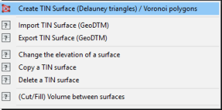
The New Surfaces Menu under Civil Tools
There has been some re-organization of tools under the Civil Tools.
All the Surface creation, editing and management operations are under a new sub-menu called Surfaces.
Under this, you now have the following commands:
(menu location changed) GT_TRIANGULATE: (GeoTools -> Civil Tools -> Surfaces-> Create TIN (Delauney triangulation) & Voronoi polygons): The menu location has changed and is now under the Surfaces sub-menu.
(menu location changed) GT_IMPORTSURFACE: (GeoTools -> Civil Tools -> Surfaces -> Import a TIN Surface (GeoTDTM)): The menu location has changed and is now under the Surfaces sub-menu.
(menu location changed) GT_EXPORTSURFACE: (GeoTools -> Civil Tools -> Surfaces -> Export a TIN Surface (GeoTDTM)) The menu location has changed and is now under the Surfaces sub-menu.
(new in V 20.06) GT_ELEVATESURFACE: (GeoTools -> Civil Tools -> Surfaces -> Change the elevation of a surface): The GT_ELEVATESURFACE is used to move all the objects in the surface by a specified amount, thus changing the elevation of the surface as a whole.
Please be aware that this command only changes the elevation of the entities in the drawing and does not change the GeoDTM file. If you need the GeoDTM file also to be updated, please run the GT_EXPORTSURFACE command.
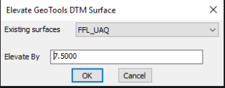
The GT_ELEVATESURFACE dialog
(new in V 20.06) GT_COPYSURFACE: (GeoTools -> Civil Tools -> Surfaces -> Copy a TIN surface): The GT_COPYSURFACE command is used to make an identical copy of a GeoDTM surface in another name.
Both the CAD entities and the .GeoDTM files are duplicated and a new data-set created. Often, it is required to make a copy of the surface so that they can be edited and compared to the original surface. This is the purpose served by this command.
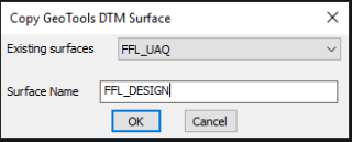
The GT_COPYSURFACE dialog
(new in V 20.06) GT_DELETESURFACE: (GeoTools -> Civil Tools -> Surfaces -> Delete a TIN surface): The GT_DELETESURFACE command is used to delete a TIN surface. Both the CAD entities and the associated .GeoDTM file are deleted.
(menu location changed) GT_SURFACEVOLUME: (GeoTools -> Civil Tools -> Surfaces -> (Cut/Fill) Volume between surfaces): The GT_SURFACEVOLUME command already existed before and now has a new home. It is now under the Surfaces menu.
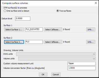
The GT_SURFACEVOLUME menu
There have been significantly improvements in this command. You can now pick named surfaces for the two surface names and the volume difference can be computed.
This is a continuously ongoing development and we will continue to refine and improve the user-experience while using this tool.
(improved) GT_DEBUGINFO: (GeoTools -> More Options -> Debuginfo): The GT_DEBUGINFO command prints our various information about your GeoTools license, running programs, installed folders and such stuff on the command line. It is a diagnostic tool designed to help support staff to pin-point the problems you may be facing with your activation/license etc.
The initial script of messages appear on the command line and later the same is copied to a dialog box and you can even save it into a text file from here. This option is provided to help users share the same with support staff.
If you are a veteran user of GeoTools, you may be able to pin-point the cause of any error or activation issue you may be facing, by simply going through the log of messages.
Other improvements and fixes:
(improved) GT_SEGLABEL: (GeoTools -> Annotation -> Label polyline segments): The Dimension option in this command has been completed and fixed. It now creates accurate dimension annotations of a closed or open polyline. In case of closed polylines, the dimensions are placed either inside or outside the polyline, and in the case of an open polyline, the dimensions can be placed either to the left or right of the direction of the flow of the polyline.
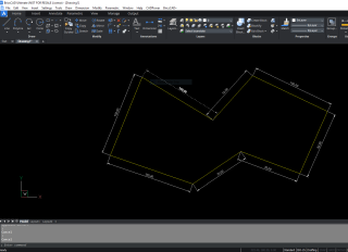
The GT_SEGLABEL command – Dimension Output
CADPower V 20.06
(improved) CP_SEGLABEL: (CADPower -> Annotation -> Label polyline segments): The Dimension option in this command has been completed and fixed.
It now creates accurate dimension annotations of a closed or open polyline. In case of closed polylines, the dimensions are placed either inside or outside the polyline, and in the case of an open polyline, the dimensions can be placed either to the left or right of the direction of the flow of the polyline.
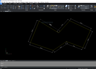
The CP_SEGLABEL command – Dimension Output
(improved) CP_DEBUGINFO: (CADPower -> More Options -> Debuginfo): The CP_DEBUGINFO command prints our various information about your CADPower license, running programs, installed folders and such stuff on the command line.
It is a diagnostic tool designed to help support staff to pin-point the problems you may be facing with your activation/license etc.
The initial script of messages appear on the command line and later the same is copied to a dialog box and you can even save it into a text file from here.
This option is provided to help users share the same with support staff.
If you are a veteran user of CADPower, you may be able to pin-point the cause of any error or activation issue you may be facing, by simply going through the log of messages.
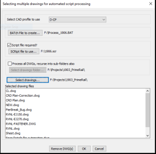
(improved) CP_BATCHPROCESS: (CADPower -> Miscellaneous -> File Management -> Batch process multiple drawings with scripts): A major revamp has been done on this command.
A number of error checks has been introduced to ensure that you select all the necessary parameters before you click the ‘Ok’ button.
This eliminates the possibility that you trying to create a script with insufficient data and result in a crash.
(bug fix – BRICSCAD only) MOVEBAK (or CP_MOVEBAK): A regression bug has been fixed in this command. The MOVEBAK operation is working good now.
A new option to make a copy of the .BAK file has been introduced. This enables the .BAK file to be copied to the specified folder as well as left in its source location (next to the .dwg file).

