GeoTools-CADPower V 19.16, 19.17, 19.18 Update ( Improved Multi-Variable Measure, Quantity Tools & Google Earth Interface)
Bengaluru, India
V 19.16, 19.17 and 19.18 of GeoTools & CADPower saw a number of small fixes and update to improve usability and productivity. In this post, we summarize some of the important new additions that has been part of these updates.
GeoTools V 19.6 / V 19.17 / V 19.18 Update
Improved command: GT_MVMEASURE: (GeoTools -> Build -> Multi-Variable Measure): The GT_MVMEASURE command has been improved.
The feedback and motivation for these improvements cam from a user in India who was using GeoTools to place railway assets along a track and needed a smarter way to do so, and be informed pro-actively of the measurements and distances.
This led us to improve the GT_MVMEASURE command.
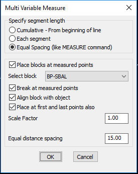
The new, improved GT_MVMEASURE dialog box
A new option to place the blocks (or points) at equal spacing (like the MEASURE command) has been added. In addition to the MEASURE commands capabilities, this option also allows to specify the block scale factor and also place one at the start and end of the line too.
Better reporting of distances
We realized it is important to tell the user what exactly happened. So, we added new information messages during the run of the command which, now tells the user exactly at what distance from the start of the polyline (or from the last added point), a new object was created.
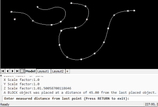
The result is what you see above.
Improved command: GT_GEIMPORTIMAGE: (GeoTools -> Geographic -> GEIMPORTIMAGE (Google Earth Image Import): The GT_GEIMPORTIMAGE command has been significantly improved, in the messaging and reporting departments.
The importing of an image from Google Earth to your CAD platform is a fundamentally manual (or semi-automatic) process that involves several steps at the CAD level and at the Google Earth level.
The messaging and prompting of the instructions have been improved. As an illustration, we reproduce again the complete set of workflow that enables this tool to perform its task.


Fixed command: GT_CHAINAGE: (GeoTools -> Civil Tools -> Annotate chainages along a route): The GT_CHAINAGE command would crash in GeoTools if it were the first command used after startup. This has been fixed now.
CADPower V 19.6 / V 19.17 / V 19.18 Update
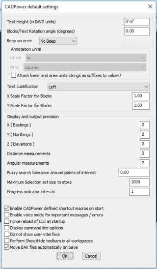
CADPower macros disabled by default now: CADPower defines a number of shortcuts, which we thought would be useful to a large number of users.
This turned out only to be partially true and the majority feedback we got that it was interfering with the existing popular shortcuts defined by most users. We have, therefore, disabled it by default in CADPower.
The shortcuts can now be enabled or disabled using the CP_DEFMACROS command or from CADPower settings.
Improved command: CP_SHOWPATHS: CADPower -> More Options -> Show system paths: The CP_SHOWPATHS command has been improved. Selecting each path item in the list now copies the same into the clipboard, even if you do not exit the dialog box with an ‘Ok’. This is a quick and handy way to copy a Windows and System paths into the clip-board.
Clicking ‘Ok’ anyway copies the selected path to clipboard and it also opens Windows Explorer with that path. Clicking ‘Cancel’ now also copies the last selected path to the clipboard but DOES NOT open Windows Explorer and browse to the path.
Improved command: CP_DWGSET: BricsCAD+ -> Support -> Drawing Settings: The CP_DWGSET command has been improved. If no template file is selected, CADPower will now reset and default to a metric template.
Havine some template is better than having no template. As on date, majority of CADPower users are in metric using countries and therefore woudl do good to have the template set to metric rather than nothing. The default template (if and only if nothing has been set already) is now default-mm.dwt.
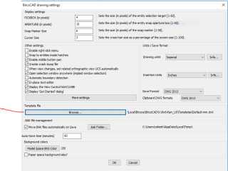
CP_DWGSET ‘Main’ dialog
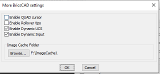
CP_DWGSET ‘More Settings’ dialog
For BricsCAD in India, Contact DesignSense
- CADPower V19 for BricsCAD: EXE (-or-) ZIP (Linux/Mac compatible)
- CADPower V19 for AutoCAD: EXE (-or-) ZIP
- GeoTools V19 for BricsCAD: EXE (-or-) ZIP (Linux/Mac compatible)
- GeoTools V19 for AutoCAD: EXE (-or-) ZIP
- BricsCAD V19: Trial download
- BricsCAD V19 Shape: Free download
- BricsCAD Communicator V19: Trial download
Key Contacts: rakesh.rao(at)thedesignsense.com / +91-9243438300 / +91-8073279755
Follow us on Twitter: https://www.twitter.com/rakesh_rao
