Major boost with GeoTools-CADPower V 17.16 Update
Bengaluru, India
CADPower & GeoTools V 17.16 Update
Major enhancement:
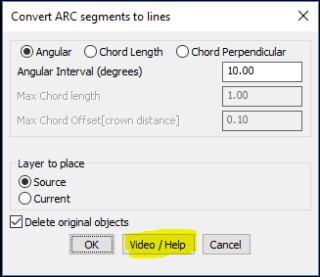
Starting this versions, we have created a ‘Video/Help’ button at the bottom of about 37 main dialog boxes.
These are primarily commands for which we already have a YouTube videos.
Going forward, we will be providing the video link to all the remaining commands during the life-cycle of V17.
Clicking on this button takes you to the online help on our website and also displays the Youtube videos if available.
If you are connected to the internet, this is a quick way to access support and help on each CADPower or GeoTools command.
We believe this is a giant step forward towards helping trial as well as paid users to access product help and videos without having to memorize URLs.
** ZIP downloads for BricsCAD versions now available
Starting this version, the English versions of CADPower and GeoTools for BricscAD will also be available as ZIP files, in addition to EXE downloads. Other language versions to follow.
The ZIP download is useful for MAC users who cannot install using Windows EXE installers.
It is also a solution for Windows firewall (or anti-virus software) issues that prevent EXE files from downloading / running and trigger misleading security alerts.
The ZIP URLs are shown next to EXE downloads on our web-site.
New command added: CP_PIECEMAKER: CADPower -> BOM/BOQ Tools -> Panels, Layout & Sizing -> Cut a linear item into pieces:
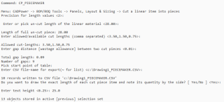
CP_PIECEMAKER Input parameters & script
The CP_PIECEMAKER command is used to schedule your cuts efficiently. Starting with a full un-cut piece of linear element, you can now easily create a quantity schedule of cut pieces.
The gap allowance also needs to be specified (optional) and the quantity schedule of cut lengths and their quantities are displayed in a CAD table as well as exported to Excel-ready CSV files. A pictorial true-to-scale representation of the cut pieces is also generated in the drawing.
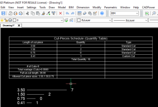
CP_PIECEMAKER Ouput
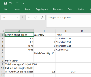
CP_PIECEMAKER Excel output & export
Enhancement:
CP_DENSIFY : CADPower -> Polyline Tools -> Vertex Management -> Densify Vertices:
GT_DENSIFY : GeoTools -> Polyline Tools -> Optimization/Cleanup -> Densify Vertices:
The Densify vertices tool now has a option to control the output, which layers they must go into and whether original objects must be retained or deleted.
Enhancement:
CP_VXLABEL: CADPower -> Annotation -> Label polyline vertices:
GT_VXLABEL: GeoTools -> Annotation -> Label polyline vertices:
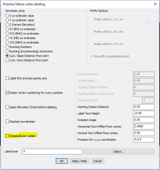
A new option has been added to align the vertex label perpendicular to the segment on which the point falls. If this option is checked, the Rotation angle is not relevant ans is greyed out.
GeoTools V 17.16 Update
Enhancement: GT_ZTREND: GeoTools -> Drawing Cleanup -> Analyze and fix polyline elevation trends:
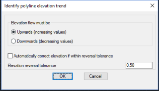
The GT_ZTREND command has been improved significantly.
This command is used to determine the trend of elevation values in polyline vertices.
For example, if you want to ensure that polylines be always of increasing or decreasing elevations, you can chose the appropriate option and determine the trend of vertex elevations.
The vertices where the elevation trend is not correct is highlighted by creating point objects at the locations in a temporary layer.
There is also a tolerance than can be applied to determine elevation reversal and an option to auto-correct elevations within a range of reverse elevations.
The reporting structure has been improved considerably. At the end of the run, it now displays the full statistics of number of vertices with Z trend errors, found, fixed, ignored, as well as creates POINT objects in a temporary layer showing locations where the trend is not as desired.
Additionally, an ASCII report file is also generated showing information from the processing.
Enhancement: GT_HSQUARE: GeoTools -> Drawing Cleanup -> Create right angle corners:
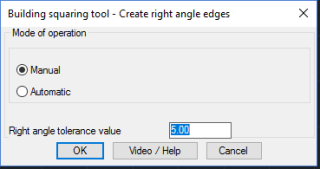
This is a tool to make two adjacent edges of a polyline into a perfect right angle. It applies the same process all along the polyline and converts a polyline with non-right angle edges into perfect right angles.
This tool was designed to make the edges of a polyline representing a digitized (or surveyed) building into accurate right angles. A number of minor enhancements and improvements has been made in this command to ensure better reporting and communication.
