GeoTools-CADPower V 20.11 & The Roadmap Ahead
Bengaluru, India

As we enter the twentieth year of GeoTools & CADPower, we look back to reflect how the products has grown over the years. We thank our customers who have been loyal users of our products and appreciate the constant feedback and inputs you guys have given us. You are responsible for the success of our product.
The users who have complained the most, sent us improvement requests and made pro-active suggestions are also our biggest power users and the most valuable for us.
GeoTools & CADPower still has a lot of room for improvement and we decided to bite the bullet to address some of those long pending issues.
The next major release: V21 is expected to release sometime in April or May 2020, and is going to be a game-changer release.
As the makeover story develops, this post is about the latest update V 20.11 and the road-map ahead.
For starters, we are in the process of creating icons for all the missing tools. For those of you who relentlessly informed us about the question marks in the toolbars and ribbon palettes, this going to be resolved (or already in process) in the next update.
The ribbons in the AutoCAD version was primitive and none existed for the BricsCAD version. Both of these are being fixed and addressed.
The 20.11 update of CADPower for BricsCAD already has a fully completed ribbon interface. We are almost through with ribbonizing the GeoTools version of BricsCAD and this will be available in V 20.12 update.
CADPower V 20.11 Update
(new feature – general) We have updated all the icons. There are no more any question marks (missing icons)

(new feature – general) CADPower commands can now be entered from another interface – RIBBON
![]()
(enhancement-general): If a drawing was un-named (not yet saved), running of any command that would create an output file would result in a default “c:/drawing1.csv” , this would result in an error as there is no write-permission on c:/ drive.
Now, the default in such cases has been changed to the TEMP folder so that the drawing output is created successfully.
(enhancement) CP_IMPEX: CADPower -> Export -> Import / Export points and lines:
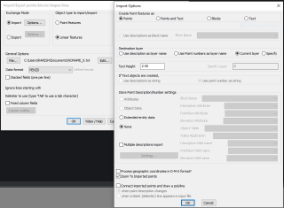
A new option has been added under the Import Options. You can now zoom to the imported data as soon as the program run is complete.
This enables you to view the imported data easily, without having to manually search and look for the same.
Additionally, a crash at the end of this command run has been fixed.
(new command) CP_CHECKHATCH: (CADPower -> Miscellaneous -> Check and compare .PAT files): The CP_CHECKHATCH command is used to compare two PAT files and report the number of same and difference hatch patterns within them.
There is also an option to merge the hatch patterns from the two files so as to have one single PAT file which has all the hatches.

The command operates in two modes – SupportFolder and Manual.
In the SupportFolder mode, it will list out all the PAT files in the support folder and ask any two of them to be selected for processing. This mode is useful when the user does know where the default PAT files may be located.
By default, the PAT files are located in the USER support folder which looks something like this:
For BricsCAD: c:\Users\RAKESH\AppData\Roaming\Bricsys\BricsCAD\V20x64\en_US\Support\default.PAT
For AutoCAD: xc:\Users\RAKESH\AppData\Roaming\Autodesk\AutoCAD\2020\……\en_US\Support\acad.PAT
In the Manual mode, you are asked to select two PAT files and the check will be performed on them as explained above.
it will list out all the PAT files in the support folder and ask any two of them to be selected for processing. This mode is useful when the user doe
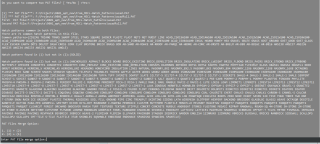
You can compare two PAT files and also merge one into another and create a third PAT file.
This is a maintenance tool and care has to be exercised to ensure that you know what you are doing.
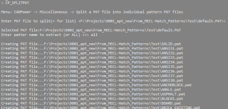
(new command) CP_SPLITPAT: (CADPower -> Miscellaneous -> Check and compare .PAT files): The CP_SPLITPAT command is used to split a larger PAT file into individual PAT files.
Smaller PAT files is often useful for checking and management, and also identify them by name, and edit if required.
(minor fix) CP_IMAGEPOLYCLIP @ CADPower -> Miscellaneous -> CAD Procedures -> Second Set -> Clip image along a closed polygon boundary
The menu location was not printed earlier when this command ran. This is fixed now.
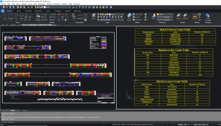
(enhancement) CP_HATCHAREA @ CADPower -> Miscellaneous -> CAD Procedures -> First Set -> Report on areas covered by HATCH
The CP_HATCHAREA command has been improved and expanded to report on hatch area by pattern, color and layer.
(bug fix) CP_IDXYZ @ CADPower -> Annotation -> Label point
The CP_IDXYZ command was doing a previous zoom restore upon exit. This has been removed based on user-feedback.
If UCS is changed, the coordinates text was still shown as WCS coordinates. This has now been fixed for XY shifted UCS, rotated UCS is still work-in-progress.
(enhancement) CP_DWG_STAT @ GeoTools -> Inquiry -> Display Drawing Statistics
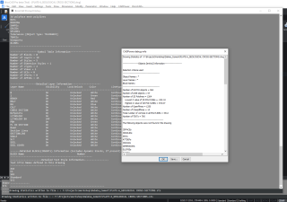
The CP_DWG_STAT command has been improved. It now allows the statistics to be saved to a file, and the same is also displayed in a text window so that the results can be scrolled and examined. This tool is still work in progress and more enhancements are on the way.
GeoTools V 20.11 Update
(enhancement-general): If a drawing was un-named (not yet saved), running of any command that would create an output file would result in a default “c:/drawing1.csv” , this would result in an error as there is no write-permission on c:/ drive. Now, the default in such cases has been changed to the TEMP folder so that the drawing output is created successfully.
(enhancement) GT_IMPEX @ GeoTools -> Export -> Import/Export points and lines: A new option has been added under the Import Options. You can now zoom to the imported data as soon as the program run is complete.
This enables you to view the imported data easily, without having to manually search and look for the same.
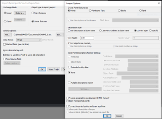
Additionally, a crash at the end of this command run has been fixed.
The elevation attribute of the GT_SURVEY_POINT block were marked with a wrong tag name of DESCRIPTION2. It is now fixed and correctly shown as ELEVATION, DESCRIPTION and POINT_NUMBER.
(bug fix) CP_LAYERAREA (CADPower -> Polyline Tools -> Inquiry Statistics -> Compute summed polyline areas from selected layers)
The CP_LAYERAREA command was not considering arc objects while reporting the lengths of linear objects in layers. This has been fixed now.
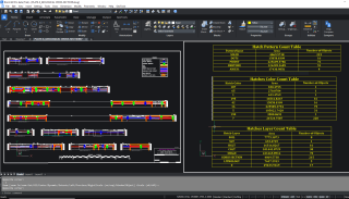
(enhancement) GT_HATCHAREA @ GeoTools -> Miscellaneous -> Report on areas covered by HATCH objects
The GT_HATCHAREA command has been improved and expanded to report on hatch area by pattern, color and layer.
(bug fix) GT_CONTOURBUILDER (GeoTools -> Civil Tools -> Create contours from TIN model)
The GT_CONTOURBUILDER command was not working if a 3dface object was selected as the TIN data. This has been fixed now and the command supports both 3dfaces and 3d polyline.
(improvement) GT_TRIANGULATE (GeoTools -> Civil Tools -> Surfaces-> Create TIN (Delauney triangulation) & Voronoi polygons)
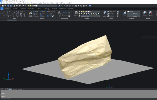
There is an improvement in the GT_TRIANGULATE command. Earlier, the surface boundary was created at an elevation of 0.0.
Now, it is created at the lowest elevation of the surface being built. This makes it easier for visualization.
(bug fix) GT_LAYERAREA at GeoTools -> Polyline Tools -> Inquiry & Statistics -> Compute summed polyline areas from selected layers
The GT_LAYERAREA command was not considering arc objects while reporting the lengths of linear objects in layers. This has been fixed now.
(bug fix) GT_IDXYZ @ GeoTools -> Annotation -> Label point
The GT_IDXYZ command was doing a previous zoom restore upon exit. This has been removed based on user-feedback.
If UCS is changed, the coordinates text was still shown as WCS coordinates. This has now been fixed for XY shifted UCS, rotated UCS is still work-in-progress.
(enhancement) GT_DWG_STAT @ GeoTools -> Inquiry -> Display Drawing Statistics
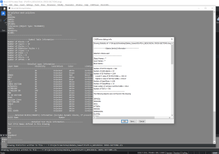
The GT_DWG_STAT command has been improved. It now allows the statistics to be saved to a file, and the same is also displayed in a text window so that the results can be scrolled and examined.
This tool is still work in progress and more enhancements are on the way.
For BricsCAD in India, Contact DesignSense
CADPower V20 for BricsCAD: EXE (-or-) ZIP (Linux/Mac compatible)
CADPower V20 for AutoCAD: EXE (-or-) ZIP
GeoTools V20 for BricsCAD: EXE (-or-) ZIP (Linux/Mac compatible)
GeoTools V20 for AutoCAD: EXE (-or-) ZIP
BricsCAD V20: Trial download
BricsCAD Communicator V20: Trial download
Key Contacts: rakesh.rao(at)thedesignsense.com / +91-9243438300 / +91-8073279755
Follow us on Twitter: https://www.twitter.com/rakesh_rao
Key Contacts: rakesh.rao(at)thedesignsense.com / +91-9243438300 / +91-8073279755
Follow us on Twitter: https://www.twitter.com/rakesh_rao
