CADPower-GeoTools Update: V 15.06a
Bangalore, India
There is a new update of GeoTools and CADPower V 15.06a. Most significantly, the user manual which has been lagging behind the current version for some time now, has been updated to reflect all the commands in the latest version.
** CADPower V 15.06a

The CADPower user manual has been updated to reflect all the latest commands and their descriptions. Both the online version on our web-site as well as the CHM is now updated.
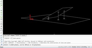
New command: CP_LINEPLANEINT: CADPower -> Miscellaneous -> CAD Procedures -> Determine the intersection of line and plane:

The CP_LINEPLANEINT command determines the intersection of a point with a plane -or- a line with a plane and marks a point at the intersection.
Use this command to create projected points or lines from points to planes.
A handy tool for geometry modeling, architectural visualization and similar design tasks.
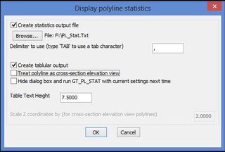
Enhancement: CP_PL_STAT: CADPower-> Polyline Tools -> Inquiry Statistics -> Compute detailed polyline statistics:

A new option has been added which allows the polyline statistics export file to be specified with a delimiter.
This allows easy import and processing of the data in Microsoft Excel.
Enhancement: CP_VISIT: Menu: CADPower -> Inquiry -> Object Selection Browser: The CP_VISIT command has been enhanced and now supports dimension as well as spline objects also.
Tip: The CP_VISIT command can be used as a tool to find the age of objects in a drawing.
If you select “All” and build a selection set of the entire drawing, you can browse through the entire collection from the first created entity to the last in exact order.
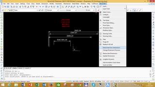
New command added: CP_DIMTXTEXTRACT (BricsCAD+ -> Extract text from dimensions):

The CP_DIMTXTEXTRACT command is used to extract the dimension text value from selected dimensions and place them on the drawing as independent text entities.
This can be a handy tool to extract dimension measurements as free standing text, which can further be used as required. For instance, you can use other CADPower tools like CP_ALIGNTEXT to align them along a reference line, CP_TXTSPACING to space them apart or CP_TXTEVAL to apply arithmetic operations on them.
** GeoTools V 15.06a
The GeoTools user manual has been updated to reflect all the latest commands and their descriptions. Both the online version on our web-site as well as the CHM is now updated.
