GeoTools-CADPower V 21.08 Update: Network License Improvements, Template Labeling
Bengaluru, India

CADPower V21.08
Network License Module improved significantly
The network licensing module in CADPower has been improved significantly in response to user requests.
It is now possible to return an activated network license back to the server. The return duration (in minutes) can be specified by the user and they will not be able to use the license for the specified duration on the computer from where it was returned.
The returned (released) license can then be used by other computers on the network. This feature enables seamless license handovers between users on a network while the others can continue to use the CAD platform without interruptions.
This is possible using three new commands which are now available on the command line only and are described as follows:
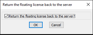
(new command) CP_FLOATING_LICENSE_RETURN: (command-line only, Returns the currently active floating license back to the server pool):

The CP_FLOATING_LICENSE_RETURN dialog in V 21.08 of CADPower
(new command) CP_FLOATING_LICENSE_REACQUISITION_TIME: (command-line only, Sets the waiting time to re-acquire the returned license from the server):

The CP_FLOATING_LICENSE_REACQUISITION_TIME dialog in V 21.08 of CADPower
By default, this is set to a value of 3 minutes.
(new command) CP_FLOATING_LICENSE_ACQUIRE_FROM_SERVER : (command-line only, Acquires a license from the license server, if one is available)
The CP_FLOATING_LICENSE_ACQUIRE_FROM_SERVER command connects to the server and checks if a valid CADPower license is available.
If yes, it will check if the time elapsed after the last return is equal or more than what was specified by the CP_FLOATING_LICENSE_REACQUISITION_TIME command. If yes, a license is allotted to this computer, else you must wait until a license is available in the pool.
When you re-start your CAD application, the license is automatically re-acquired if available in the network pool.
GeoTools V21.08
Network License Module improved significantly
The network licensing module in GeoTools has been improved significantly in response to user requests. It is now possible to return an activated network license back to the server.
The return duration (in minutes) can be specified by the user and they will not be able to use the license for the specified duration on the computer from where it was returned.
The returned (released) license can then be used by other computers on the network. This feature enables seamless license handovers between users on a network while the others can continue to use the CAD platform without interruptions.
This is possible using three new commands which are now available on the command line only and are described as follows:
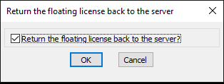
(new command) GT_FLOATING_LICENSE_RETURN: (command-line only, Returns the currently active floating license back to the server pool):

The GT_FLOATING_LICENSE_RETURN dialog in V 21.08 of GeoTools
(new command) GT_FLOATING_LICENSE_REACQUISITION_TIME: (command-line only, Sets the waiting time to re-acquire the returned license from the server):

The GT_FLOATING_LICENSE_REACQUISITION_TIME dialog in V 21.08 of GeoTools
By default, this is set to a value of 3 minutes.
(new command) GT_FLOATING_LICENSE_ACQUIRE_FROM_SERVER : (command-line only, Acquires a license from the license server, if one is available)
The GT_FLOATING_LICENSE_ACQUIRE_FROM_SERVER command connects to the server and checks if a valid GeoTools license is available.
If yes, it will check if the time elapsed after the last return is equal or more than what was specified by the GT_FLOATING_LICENSE_REACQUISITION_TIME command. If yes, a license is allotted to this computer, else you must wait until a license is available in the pool.
When you re-start your CAD application, the license is automatically re-acquired if available in the network pool.
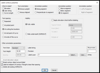
(improved commands) GT_CONTLABEL (GeoTools -> Annotation -> Label contour polylines):
and
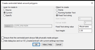
GT_CREATECENTROID (GeoTools -> Build -> Create centroid marks inside closed polygons):


We received an SOS request from one of our users who wanted to label hundreds of closed polylines (on different layers) with the layer name at the centroid of the polygon. We did not have a ready tool for this, so we have introduced in GT_CREATECENTROID and GT_CONTLABEL the ability to use a special string called #layername .
If you choose the label type as user string and define the user string as #layername, it will get replaced with the actual layer name while labeling.
For BricsCAD in India, Contact DesignSense
BricsCAD V20: Trial download
BricsCAD Communicator V20: Trial download
CADPower V21 for BricsCAD: EXE (-or-) ZIP (Linux/Mac compatible)
CADPower V21 for AutoCAD: EXE (-or-) ZIP
GeoTools V21 for BricsCAD: EXE (-or-) ZIP (Linux/Mac compatible)
GeoTools V21 for AutoCAD: EXE (-or-) ZIP
Key Contacts: rakesh.rao(at)thedesignsense.com / +91-9243438300 / +91-8073279755
Follow us on Twitter: https://www.twitter.com/rakesh_rao
