GeoTools-CADPower V 21.06 Update: Improvements to Parcel labeling, Data Extraction and More
Bengaluru, India
CADPower V21.06
Portuguese Version Improvements:
All the dialog boxes have now been completely translated into Portuguese (Brazilian) in the PTBR version of CADPower, for AutoCAD and BricsCAD. This is an ongoing development and continues in each update.
Peeking into XREFs:
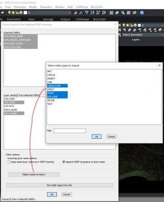
(new command) CP_XTRACTXREFLAYERDLG: (CADPower -> Miscellaneous -> CAD Procedures -> First Set -> Extract selected layers from multiple XREFs):

The CP_XTRACTXREFLAYERDLG command provides a dialog-box driven user interface to select multiple layers from attached xrefs and import them into your CAD drawing.
You can also filter and import only specific types of objects from selected layer(s).
The destination layer name also can be controlled. If you want to pick an object from the XREF and query its layer, there is a button called ‘Pick XREF for layer info’.
You can use this to pick an object and determine its layer and the XREF name in a quick manner.
This tool makes it easy for you to extract one of a few layers from an XREF without having open or bind it or resort to CAD techniques like Copy-Paste etc. It is an elegant way to work with attached drawings and selectively make filtered data from such drawings a part of your current drawing.
GeoTools V21.06
German Version Improvements:
The German versions of GeoTools for BricsCAD now has more complete translation in the pull-down menu section. This is an ongoing development.
Portuguese Version Improvements:
All the dialog boxes have now been completely translated into Portuguese (Brazilian) in the PTBR version of GeoTools, for AutoCAD and BricsCAD. This is an ongoing development and continues in each update.
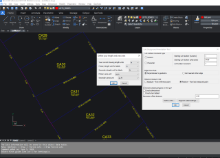
(improved) GT_LOTMAKER: Menu: GeoTools -> Draw -> Parcel-Lots -> Draw Parcel-Lots: The GT_LOTMAKER command has been significantly improved. It is now able to correctly generate lot labels automatically across street boundaries that are winding and across road corner bends.
 The main GT_LOTMAKER dialog box
Using the Define Units section in the main dialog box, you can now define the drawing unit, primary length and area unit, secondary length and area units and accordingly, additional secondary units will be displayed in the drawing. In the above example, you can see that the primary length unit is meter and the area unit is sq.m.
The secondary units are ft and sq.ft. Accordingly, the labeling is done.
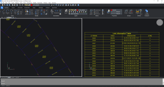
The GT_LOTMAKER command also automatically creates an object table called LOTS_TABLE and the lot name, area, dimensions and a zone number field is created by default.
Once the lots information is created in the object table, you can then create a CAD table out of it using the GT_CPOD_TABLEDATA command.
 The LOTS_TABLE object table info represented as a CAD table
For BricsCAD in India, Contact DesignSense
BricsCAD V20: Trial download
BricsCAD Communicator V20: Trial download
CADPower V21 for BricsCAD: EXE (-or-) ZIP (Linux/Mac compatible)
CADPower V21 for AutoCAD: EXE (-or-) ZIP
GeoTools V21 for BricsCAD: EXE (-or-) ZIP (Linux/Mac compatible)
GeoTools V21 for AutoCAD: EXE (-or-) ZIP
Key Contacts: rakesh.rao(at)thedesignsense.com / +91-9243438300 / +91-8073279755
Follow us on Twitter: https://www.twitter.com/rakesh_rao
