GeoTools-CADPower V 21.04 Update
Bengaluru, India

Addition of tools in beta mode: GeoTools-CADPower V 21.04 Update:The twin productivity add-ons, GeoTools & CADPower have been updated again. We are pleased to release V 21.04 update for you, a better finished one than the 21.03.
CADPower V 21.04
In V 21.03 we added a few tools in beta mode. These have been updated again and elevated to release status now in V 21.04. They are now available in the pull-down menus, toolbars and the ribbons. For the purpose of completeness, we will carry the full-feature description of these tools again in this post.
(New command):CP_EXCELQUERY: (CADPower -> Build -> CADPower Object Data -> Query and Insert data from Excel sheet):
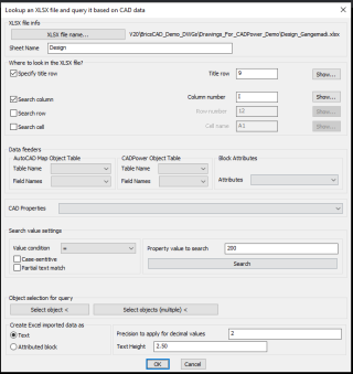
CP_EXCELQUERY dialog
The CP_EXCELQUERY command is a multi-purpose command to read a specified sheet from XLSX files and query the data based on rows and columns, match them with CAD data using logical conditions and generate tables or MTEXT or attributed block with the returned information.
Most CAD data need often to be compared with Excel data and a bridge was required. CADPower provides it now.
This is also in line with our roadmap to offer more .dwg and Excel data mining tools within CADPower.
The use-case for this: What is the problem it solves?
You have an Excel sheet and you have a CAD drawing. You need to match the content in the Excel sheet based on your CAD data and pull out relevant information. This command has the solution.
There are two sets of information that you need to specify in this main dialog box.
The first set pertains to the XLSX workbook name and the SheetName where you need to look for the data.
Next, you need to specify the rows and columns you want to search.
The first item in this list is the location of the Title row: usually Excel sheets have the title info specified in one of the rows. You need to specify that row number here.
In the Search Column and Search Row sections, you need to specify a row or column name that you want to quick-search.
The results are displayed instantly in a popup window opened by the Show buttons and copied to clipboard and/or placed as MTEXT or attributes block on the drawing.
There is a Search Cell option also to retrieve the value of a single cell.
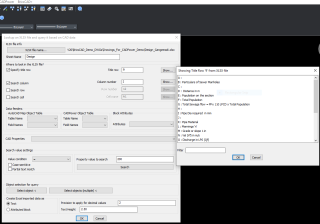
The TitleRow Info from the Excel sheet
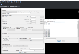
The results of a queried column
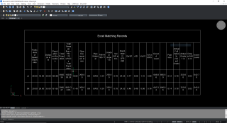
The results of a query from XLSX displayed as table in CAD
The next section is called Data Feeders where you can get CAD data from selected object(s) or enter your own independent search data.
Data from your drawing can either come from an AutoCAD Map Object table, CADPower object data or from inherent CAD properties like Length, Area, block attribute, text value, radius, elevation, color, rotation angle etc.
The complete list of CAD properties that you can use are shown in the image below:
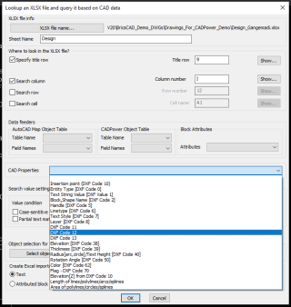
CAD properties that can be queried from XLSX
The next set of information you need to provide is about the CAD entity that you want to use for query.
Clicking on the Select button allows you to pick an entity that will offer its internal CAD properties or attached object table or attribute data for query.
You need to make the right selections from the Data Feeders and get the property value that you want to query.
You can also specify logical operators on the data and perform the query based on whether you want an exact match, less than or greater than or not equal to the value (for integer and real values).
For string values, you can search based on their case, or even partial search and so on.
All the search conditions you specify here will be taken into consideration when searching the XLSX data.
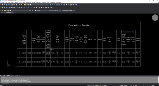
Excel data read in and displayed as table
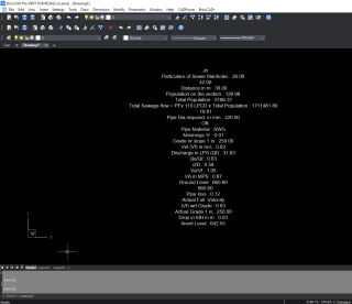
Excel data read in and displayed as MTEXT
(New command): CP_XTRACTXREFLAYER: (CADPower -> Miscellaneous -> CAD Procedures -> First Set -> Extract layer from Xref):The CP_EXTRACTXREFLAYER is an super-charged extension of the existing CP_XTRACT command and can extract a complete layer of dwg data from an attached external reference drawing and import them into current drawing.
This is an easy way to selectively extract information from XREFs into your current drawing.
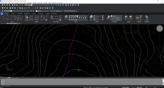
The CVD-CONT contours layer extracted from an attached XREF by a single pick
GeoTools V 21.04
A new set of dedicated tools for creation of property lots and labeling have been introduced.
They are now available in the pull-down menus, toolbars and ribbons as well. These tools were announce in V 21.03 in beta stage and are now in release stage.
However, these are continuously evolving tools and the parcel annotation tools journey has just begun.
GT_LOTMAKER(GeoTools -> Draw -> Parcel-Lots -> Draw Parcel-Lots): The GT_LOTMAKER command is a semi-automatic tool for creating parcel lots (or property lots in some countries).
It is a combination of polygon annotation and automatic boundary generation tools that enables the best possible automated method to create parcel lots meeting some criteria in design.
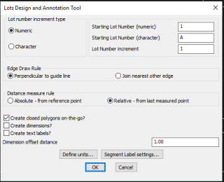
GT_LOTMAKER main dialog
The main interface of GT_LOTMAKER allows you to specify basic parameters like lot number, increment type, boundary(edge) drawing rules, labeling options, etc.
Detailed labeling options can be set using the GT_SEGLABEL settings dialog which can be called from within this dialog itself.
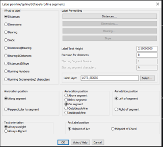
Segment labeling options (from GT_SEGLABEL dialog)
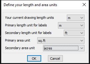
Drawing Units, Length, Area, primary, Secondary units settings
The lots labels for the linear and area units can be specified in a primary unit and a secondary unit.
Additionally, you can also perform a units conversion when length or area units are annotated. All of this can be specified in the length and area settings dialog box.
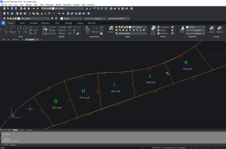
Output from GT_LOTMAKER command
GT_LOTSLABELER (GeoTools -> Draw -> Parcel-Lots -> Parcel-Lots labeling): The GT_LOTSLABELER command is used to label closed polyline using the currently set parameters as per the dialog boxes used by the GT_LOTMAKER command.
GT_CLINE (GeoTools -> Draw -> Parcel-Lots -> Draw centerlines from guidelines): The GT_CLINE command is a center-line generator command. It is used to draw the center-line between two guide lines. Typically, while drawing parcel lots.
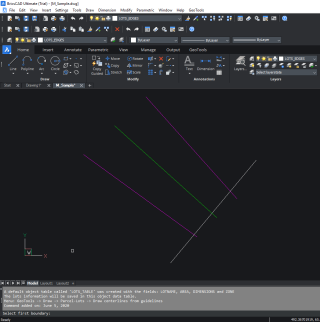
GT_CLINE output – the center line drawn between two guidelines
GT_EDGECLOSE (GeoTools -> Draw -> Parcel-Lots -> Clean lot boundaries by snap/trim): The GT_EDGECLOSE command is a tool meant to clean up parcel lot edges (lines, polylines, arcs, splines) by making them snap to their nearest neighbor objects.
This is done either by closing small gaps or trimming overshoots, which are withing a specified tolerance.
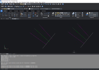
GT_EDGECLOSE output – with cleaned edges, undershoots and overshoots cleaned
For BricsCAD in India, Contact DesignSense
BricsCAD V20: Trial download
BricsCAD Communicator V20: Trial download
CADPower V21 for BricsCAD: EXE (-or-) ZIP (Linux/Mac compatible)
CADPower V21 for AutoCAD: EXE (-or-) ZIP
GeoTools V21 for BricsCAD: EXE (-or-) ZIP (Linux/Mac compatible)
GeoTools V21 for AutoCAD: EXE (-or-) ZIP
Key Contacts: rakesh.rao(at)thedesignsense.com / +91-9243438300 / +91-8073279755
Follow us on Twitter: https://www.twitter.com/rakesh_rao
