A Brand New Levels Tools Debuts: GeoTools-CADPower releases V 21.10 – 21.16
Bengaluru, India

The past few weeks have been hectic for us and we have been on an over-drive updating GeoTools & CADPower. GeoTools-CADPower releases V 21.10 – 21.16
During this time, we released V 21.10, 21.11, 21.12, 21.13, 21.14, 21.15 and 21.16 but there was no chance to pause and send out a notification or blog post about each one of them.
So, here is a consolidated post:
GeoTools Updates
(improved) GT_CCPOLY : (GeoTools -> Build -> Create closed polylines from a mass of networked polylines):
The GT_CCPOLY command is used to create topology polygons, and has been significantly improved.
Rigorous testing was done using special use-cases with user-data, significant performance and UI messaging improvements done.
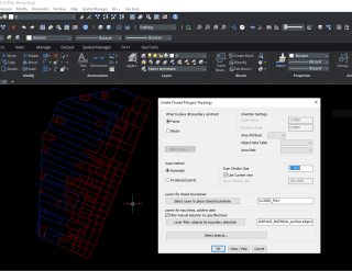
In addition, a new youtube movie has been made showing the new topology creation functions in this update.
(improved) GT_SHEETINS : (GeoTools -> Civil Tools -> Create and Place Map Sheet Index Block):
The GT_SHEETINS command was improved significantly. It is now possible for you to create and insert multiple map sheets in a looped operation without having to call the command again and again.
The dragging of the sheet rectangle with the specified size gives user a better control.
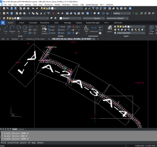
We created a workflow video for you to show how to insert multiple sheets into a 30-km survey stretch and be able to manage the layout and viewing of the sheets same also be able to
(new) GT_MAPSHEETZOOM: The GT_MAPSHEETZOOM command is used to select a map sheet block created by GeoTools and zoom to the extents of it in the current model space or paper-space view-port.
This command is yet to be added to the user-interface (as of 21.15) and is accessed on the command-line only.
Please watch the above video to learn how to use this command.
CADPower Updates
(new-Beta): CP_LEVELIT: A new tool for levels management has been created in V 21.15 of CADPower and it is called CP_LEVELIT. It is in beta mode at the moment, as of V 21.16.
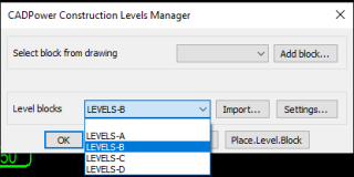
The CP_LEVELIT Main dialog
The CP_LEVELIT command allows to place blocks at different level locations in your drawing and automatically annotate the level, whic is stored as an attribute of the block.
The CP_LEVELIT command seeks inspiration from a popular AutoCAD add-on called COMSLevelIt, which is not available for BricsCAD.
Based on several customer requests, we decided to bring in the same set of features for BricsCAD users also.
CP_LEVELIT command offers a few pre-defined template blocks called Levels-A, Levels-B and Levels-C which can be used readily as level blocks.
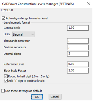
CP_LEVELIT Settings
Each levels block can be setup as per user-controllable settings as shown in the dialog box above.
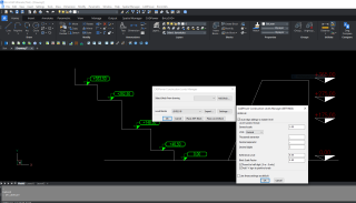
Output illustration
The above image shows the levels blocks in use in a drawing depicting various levels.
The CP_LEVELIT video
If you want to create your own level blocks, you can do so. You just need to make sure that the insertion point is at the correct place and the elevation attribute must be named ELEVATION.
CP_DWGSET: (BricsCAD+ -> Support -> Drawing Settings): The CP_DWGSET command was improved with the addition of the option to set the GRIPS size.
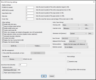
General updates to both GeoTools & CADPower
The network (floating) licensing module has been improved significantly.
Three new maintenance commands were added which make it easier to manage the floating license easily.
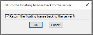
CP_FLOATING_LICENSE_RETURN: The CP_FLOATING_LICENSE_RETURN command is used to return the floating (network) license back to the server.
CP_FLOATING_LICENSE_REACQUISITION_TIME: The CP_FLOATING_LICENSE_REACQUISITION_TIME command is used to specify the time (in minutes) that needs to elapse before the license can be re-acquired back from the server.

CP_FLOATING_LICENSE_ACQUIRE_FROM_SERVER: The CP_FLOATING_LICENSE_ACQUIRE_FROM_SERVER command acquires the license back from the server if available and if the requisite time has passed since the last return.
GeoTools & CADPower are now BricsCAD V21 Compatible
V 21.16 of GeoTools and CADPower are now BricsCAD V21 compatible! If you are in active subscription, just make sure you download and install V 21.16 in order to be able to use our software on BricsCAD V21.
New Online User Manual (early beta version)
We are reworking our user manuals and a the first cut of our early beta HTML version is now available on our web-site. We request you to check this out and give us your feedback and comments.
For BricsCAD in India, Contact DesignSense
BricsCAD V21: Trial download
BricsCAD Communicator V21: Trial download
CADPower V21 for BricsCAD: EXE (-or-) ZIP (Linux/Mac compatible)
CADPower V21 for AutoCAD: EXE (-or-) ZIP
GeoTools V21 for BricsCAD: EXE (-or-) ZIP (Linux/Mac compatible)
GeoTools V21 for AutoCAD: EXE (-or-) ZIP
Key Contacts: rakesh.rao(at)thedesignsense.com / +91-9243438300 / +91-8073279755
Follow us on Twitter: https://www.twitter.com/rakesh_rao
