GeoTools-CADPower V 20.14 Update, Entirely home made: Digital Elevation Model, Civil Surface Interpolation Tools & Smart 3D Offsets
Bengaluru, India

As we work from home due to COVID-19, this is actually offering us quality time without distractions to build some cool new tools and enhancements to GeoTools & CADPower. Here is V 20.14 update for you, completely home-made.
CADPower V 20.14 Update
Bug fix/enhanced command: CP_BOM: CADPower -> BOM/BOQ Tools -> Create Bill of Materials/Quantities:
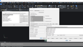
The CP_BOM command has been enhanced and bug-fixed. There was a discrepancy in the way the blocks were selected for processing when the ‘Multiple Named Blocks’ option was chosen as the BOM-Q workflow.
The question was whether the blocks defined in the INI file rules or the blocks selected in the main dialog window are processed.
This has been resolved – the program now always processes only those blocks that are defined in the INI file.
When you now make a selection of blocks in the INI files, the same selection choices are reflected in the dialog box also.
To give you a quick primer, the ‘Multiple Named Blocks’ workflow of the CP_BOM command lists all the blocks defined in the current drawing in the main dialog window and you can choose all or some of those blocks and have then transferred to INI file as a template.
You can then edit the INI and provide meaningful descriptions, cost and time parameters for each of those blocks.
Earlier, the program would process blocks selected in the main dialog window.
This has been changed now – for consistency. The program will now process all blocks which are specified in the INI file and the same blocks are automatically selected (marked) in the main dialog also.However, the processing happens on the INI blocks only even if the user were to deselect blocks in the main dialog later.
This ensures a kind of discipline that all (and only) INI marked blocks will be eligible for processing.
Enhanced/fixed command: CP_ANGLABEL: CADPower -> Annotation -> Label Polyline Angles:
The CP_ANGLABEL command has been bug-fixed and improved. The angle labeling of interior, exterior or both (for closed polylines) and left, right or both (for open polylines) has been now checked thoroughly and made consistent and bug-free.
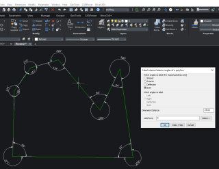
The CP_ANGLABEL command and its output on a closed polyline
A quick primer: The CP_ANGLABEL allows closed and open polyline segment angles to be annotated with a dimension.
The location of the dimension can be inside, outside, left or right of the polyline.
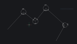
CP_ANGLABEL processed on an open polyline
(enhanced): CP_MOFFSET: CADPower -> Build -> Offset -> Multiple-Offset relative/absolute

The CP_MOFFSET command has been improved. The offset distance entered will now be remembered as default and further offsets of the same value can be applied by simply hitting the ENTER key repeatedly.
As you can see above, there are two new features added. The <C>ontinue option will allow multiple offsets to be done in the inside direction until no more is possible.
The 3D Offset option will allow the next offsetted polyline to be raised (or lowered) as per the Z increment specified.
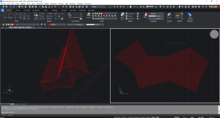
Output from CP_MOFFSET command using 3d offset and Continue option
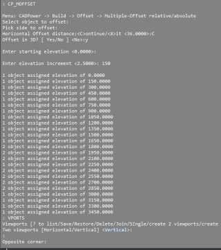
Trsnscript showing the elevations of polyline as they get ofsetted in 3D by the specified distance
GeoTools V 20.14 Update
(redesigned) GT_PTINTERUATOMATIC: GeoTools -> Build -> Interpolate point elevation from neighboring polylines/3dfaces
The GT_PTINTERUATOMATIC command has been completely re-written from scratch and we may call it new as well.
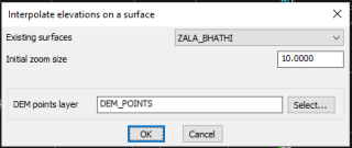
The command is now Surfaces-aware and can work on the defined surfaces. If the surface is not imported in the drawing, you will be prompted to import the terrain surface first.
You can select blocks and points and they will be assigned elevations based on neighboring polylines and 3dfaces (from the surface specified).
There is also an option to not select any surface. In that case, you will be prompted to select closed polylines or 3dfaces from which the elevations can be acquired and populated.
(new command): GT_DEMGRID: GeoTools -> Civil -> Create a DEM grid from surface data:
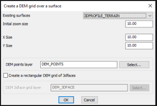
GT_DEMGRID dialog box
The GT_DEMGRID is a command that has been requested for some time now and we are happy to announce that it is ready and released.
The Digital Elevation Model (DEM) grid is a regular rectangular grid of a fixed, regular dimension in X and Y. This command works on a defined surface and you must choose it from the list. The surface must be imported in the drawing, if not already present.
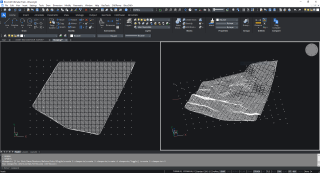
Rectangular Digital Elevation Model (DEM) grid across a surface
You can use this command to interpolate across a surface and create a grid of points at regular XY interval.
In the next update (20.15), it is planned to connect the rectangular dots and create a 3dface grid of the entire data. We will also be working on exporting the DEM data to an Arc ASCII DEM file.
(enhanced command): GT_DRAWGRADE: GeoTools -> Civil Tools -> Draw Graded polylines:
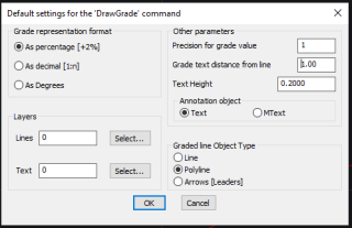
The GT_DRAWGRADE command now has an option to create the grade annotation as either Text or MText. This feature will be gradually extended to other commands also.
GeoTools-CADPower Direct downloads
CADPower V20 for BricsCAD: EXE (-or-) ZIP (Linux/Mac compatible)
CADPower V20 for AutoCAD: EXE (-or-) ZIP
GeoTools V20 for BricsCAD: EXE (-or-) ZIP (Linux/Mac compatible)
GeoTools V20 for AutoCAD: EXE (-or-) ZIP
For BricsCAD in India, Contact DesignSense
BricsCAD V20: Trial download
BricsCAD Communicator V20: Trial download
Key Contacts: rakesh.rao(at)thedesignsense.com / +91-9243438300 / +91-8073279755
Follow us on Twitter: https://www.twitter.com/rakesh_rao
