GeoTools-CADPower V 20.13 Update: Stepped 3d Polyline, Island Areas and Contours From Surfaces
Bengaluru, India

GeoTools V 20.13 Update
New command added: GT_ISLANDAREA: (Menu: GeoTools -> Inquiry -> Island area detection):
The GT_ISLANDAREA command is used to determine the net area of a bounding polygon minus the area of all polygons completely within it.
The bounding polygon can be a closed polyline, spline or a circle. You must select a set of objects that are all within the outer enclosing closed polygon and the net area of the biggest polygon minus the inside polygons will be reported. The net area can be created as a text label.
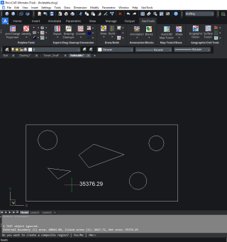
GT_ISLANDAREA output
At the end of the command, you have the option to convert the resulting geometry into a REGION.
New command added: GT_STEPPED3DPOLY: (Menu: GeoTools -> Civil Tools -> Draw stepped 3d polylines):
The GT_STEPPED3DPOLY command is used to draw a stepped 3d polyline. A stepped 3d polyline is one that crosses any 3D intersection in its path and creates a stepped polyline that is drawn horizontal from the previous point until the next intersection point and then rises vertically upwards.
In some ways, this command is similar to the GT_DRAPEPOLY command. While GT_DRAPEPOLY command joins the actual 3d intersection of all items in its path, the GT_STEPPED3DPOLY command draw the same with a stepped effect, thereby keeping the segments exactly horizontal or vertical.
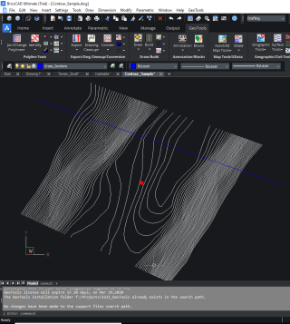
GT_STEPPED3DPOLY input
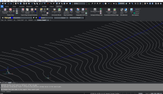
GT_STEPPED3DPOLY output
Improvement: GT_IMPEX: GeoTools -> Export -> Import / Export points and lines:
After importing data from the CSV files, there is now an option to zoom to the imported data.
Improvement: GT_CONTOURBUILDER: GeoTools -> Civil Tools -> Create contours from TIN model
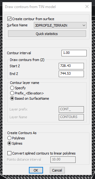
GT_CONTOURBUILDER dialog
The GT_CONTOURBUILDER command has been improved significantly. It is now possible to select the surface and draw the contours from the surface data.
The surface data must be available as 3dface or 3d polyline objects in the designated surface layer.
If you do not have a defined surface, you can select 3dfaces or 3dpolylines manually also. In that case, you must disable the check mark at the top ‘Create contours from surface’.
CADPower V 20.13 Update
New command added: CP_ISLANDAREA: (Menu: CADPower -> Inquiry -> Island area detection):
The CP_ISLANDAREA command is used to determine the net area of a bounding polygon minus the area of all polygons completely within it.
The bounding polygon can be a closed polyline, spline or a circle. You must select a set of objects that are all within the outer enclosing closed polygon and the net area of the biggest polygon minus the inside polygons will be reported.
The net area can be created as a text label.
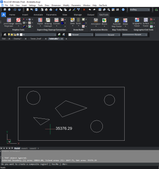
CP_ISLANDAREA output
At the end of the command, you have the option to convert the resulting geometry into a REGION.
Bug fix: CP_FILTER @ CADPower -> Selection -> Object selection FILTER: (BricsCAD only)
The FILTER command was crashing in a trial version of CADPower. This has been fixed.
Enhancement: CP_HOLETABLE @ CADPower -> Draw -> Rule-Based -> Hole table:
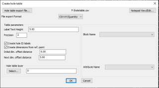
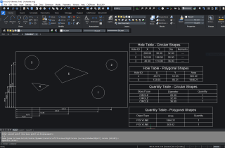
The CP_HOLETABLE command has been improved. It is now possible to display the distances of the holes from the origin by way of horizontal and vertical dimensions.
Bug fix: CADPower-> Conversion-> Polyline/3DFace/Mesh-> Convert polylines to 3dFace:
The CP_PL23DFACE command was converting 2d polylines with elevation into 3dfaces with zero elevation. This has been fixed.
Improvement: CP_IMPEX: CADPower -> Export -> Import / Export points and lines:
After importing data from the CSV files, there is now an option to zoom to the imported data.
GeoTools-CADPower Direct downloads
CADPower V20 for BricsCAD: EXE (-or-) ZIP (Linux/Mac compatible)
CADPower V20 for AutoCAD: EXE (-or-) ZIP
GeoTools V20 for BricsCAD: EXE (-or-) ZIP (Linux/Mac compatible)
GeoTools V20 for AutoCAD: EXE (-or-) ZIP
For BricsCAD in India, Contact DesignSense
BricsCAD V20: Trial download
BricsCAD Communicator V20: Trial download
Key Contacts: rakesh.rao(at)thedesignsense.com / +91-9243438300 / +91-8073279755
Follow us on Twitter: https://www.twitter.com/rakesh_rao
